

A nor’easter in May? Yes, it can happen, and that’s exactly what’s on tap this week across the Northeast.
The FOX Forecast Center wants you to remember that a nor’easter doesn’t require snow; it is characterized by a low-pressure area with powerful northeasterly winds coming from the Atlantic Ocean.
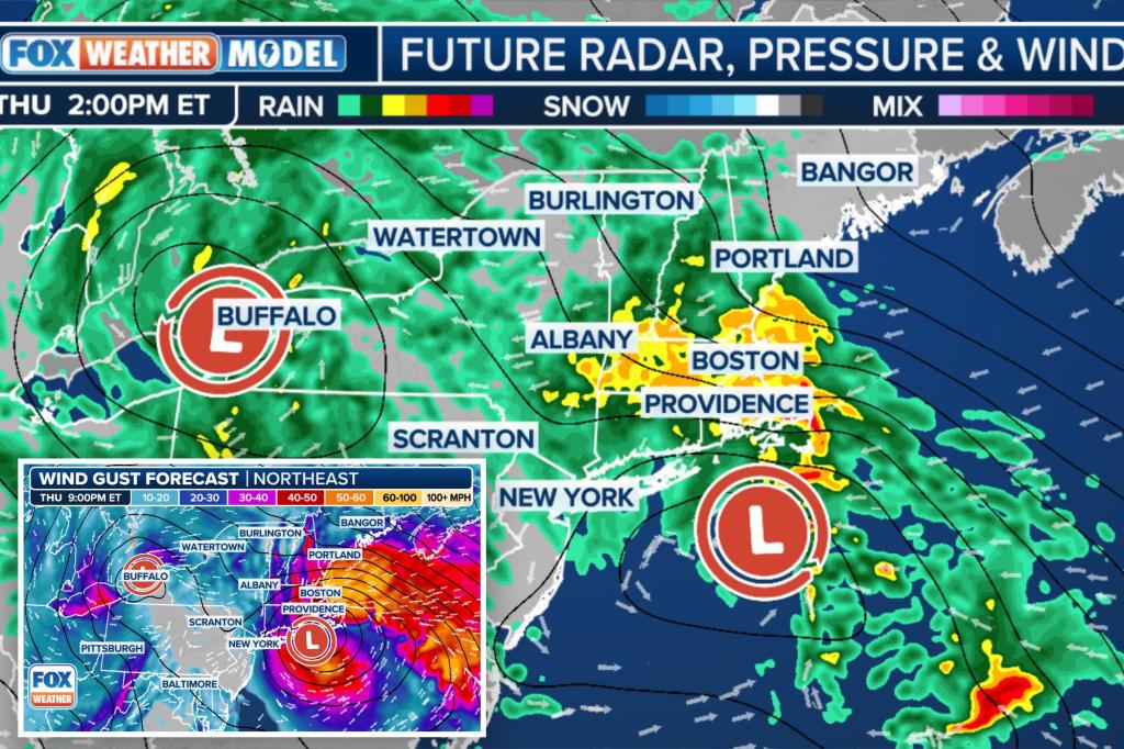
Two areas of low pressure will form this week – one across the interior and another off the East Coast.
The coastal low will become a weak nor’easter as it crawls northward across eastern New England on Thursday.
What does this mean? It means a few unpleasant days ahead for those hoping to kick off the Memorial Day weekend early, as they’re likely to encounter chilly, wind-driven heavy rain.
The rain will begin Wednesday from the Great Lakes through the mid-Atlantic courtesy of the interior low, the FOX Forecast Center said.
Those in cities like Philadelphia, Detroit and Milwaukee will experience a day more reminiscent of March with a steady rain and highs in the 50s.
Starting Wednesday night, the coastal low pressure will begin to take shape south of Long Island, New York.
This low-pressure system is expected to grow stronger, and this mild nor’easter is set to reach its peak on Thursday, bringing a consistent, and at times heavy, rainfall from the New York City tri-state area all the way to New England.
Rain totals will generally remain around 1-2 inches, with locally higher amounts over higher elevations and right along the Northeast and New England coasts, closer to the area of low pressure. Flash flooding is not expected.
Winds will also be a problem, especially from eastern Long Island up through the New England coast. Wind gusts could exceed 40 mph, with some 50-plus mph gusts possible.
While winds of this strength won’t take down too many trees, they will likely lead to delays at the major Northeast airports, especially Boston, on Thursday. They will also just add to the already-miserable conditions outside.
The strong northeasterly winds will also raise water levels at the coast. While astronomical tides are not that high, a 1.5- to 2.5-foot water rise is still possible. If this occurs, minor coastal flooding will be possible from the Jersey Shore to southern Maine during the Thursday evening high tide, the FOX Forecast Center warns.
Along with the rain, temperatures will fall well below average. In New York City, for example, high temperatures will be stuck in the mid-50s on Wednesday and Thursday. This is almost 20 degrees below average for late May.
Fortunately, unlike recent weekends, most of the Northeast is expected to dry out by Saturday and Sunday, with some sunshine returning to the coast. Some lingering showers may hang around across the interior Northeast and New England.
Sunday and Memorial Day will be dry, albeit cool, with highs in the 60s.