
Share this @internewscast.com
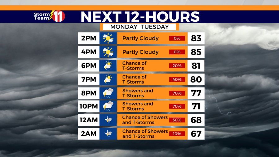
A mild and muggy evening is on tap for the Tri-Cities. A line of scattered showers and thunderstorms is expected to move through from 6 to 9 p.m.

Scattered strong to severe thunderstorms will be possible during that time, with the primary threat being damaging winds.


A passing shower or thunderstorm is possible tonight, with a low of 63 degrees.

Tuesday will begin with cloud cover, but skies will gradually clear as the day progresses, reaching a high of 80 degrees. Overnight, expect mostly clear conditions with temperatures dropping to a low of 56 degrees.

Skies will be mostly sunny on Wednesday with a high of 83 degrees. Wednesday night will be mostly clear with a low of 60 degrees.
On Thursday, anticipate partly cloudy skies and a peak temperature of 87 degrees. There is a 20% chance of isolated showers and thunderstorms likely influenced by the terrain. The night will see mostly cloudy conditions and a low of 63 degrees.
Friday brings a 50% chance of scattered showers and thunderstorms with temperatures again hitting a high of 87 degrees. As night falls, there might be an occasional shower or thunderstorm early on, leading to generally cloudy skies and a low of 65 degrees.
Showers and thunderstorms are likely on Saturday with a high of 86 degrees. The rain chance will be 70%. Scattered showers and a few thunderstorms will be possible Saturday night with a low of 67 degrees.
More showers and thunderstorms are expected on Sunday under mostly cloudy skies. The rain chance is 80% with a high of 85 degrees.
Next Monday will be somewhat cooler under cloudy skies, There will be a 40% chance of scattered showers with a high of 79 degrees.
Have a great evening and stay weather aware.