
ORLANDO, Fla. – With the peak of the Atlantic hurricane season approaching, there are increasing indications of activity, making it crucial to be vigilant.
Tropical Storm Erin is advancing westward through the central Atlantic, while other regions exhibit minor prospects for development.
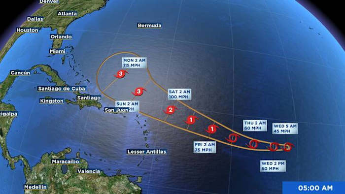
Tropical Storm Erin
Erin is currently spinning in the central tropical Atlantic and struggling a bit to organize.
Easterly wind shear and mid-level dry air are preventing the storm from strengthening significantly, sustaining winds at approximately 45 mph in the coming days.
However, conditions are expected to improve by late week as Erin.
Most forecast models agree that Erin could become a hurricane by the weekend, making it the first one of the 2025 season.
Erin is moving west and will likely begin to turn slightly more north in a couple of days as a Bermuda High to its north begins to weaken.
This potential turn in the track is something we will be closely watching closely.
The latest National Hurricane Center forecast projects Erin on the southern route of recent models, likely nearing the northern Leeward Islands, Virgin Islands, and Puerto Rico by the upcoming weekend.
Although it’s early to determine the storm’s potential strength or proximity, residents in these areas should remain watchful and up-to-date with forecasts.
Many models show Erin finding a weakness in the ridge, allowing the storm to bend away from U.S., but at this point that is not a guarantee.
Make sure to stay up to date through the weekend.
Elsewhere in Tropics
In the southwestern Gulf, a tropical wave currently moving across the Yucatán Peninsula is producing scattered showers and storms.
There is a slim possibility of the storm becoming more structured over the warm Bay of Campeche waters this week. Currently, development odds are low—10% in the next 48 hours and 20% over the subsequent seven days.
In the northwestern Atlantic, a non-tropical low-pressure system is still spinning a few hundred miles southeast of Nova Scotia.
While it’s tapping into the Gulf Stream’s warmer waters and producing some thunderstorms, it’s likely too far north for tropical development to take hold. It will move over cooler waters by Wednesday night, ending any development chances.
Copyright 2025 by WKMG ClickOrlando – All rights reserved.