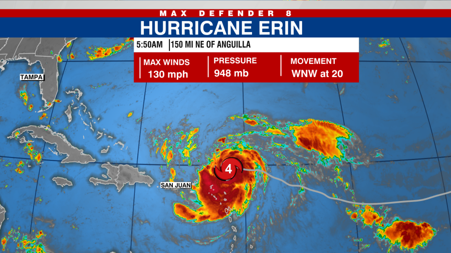

TAMPA, Fla. (WFLA) — As of 5:50 a.m. on Saturday, Hurricane Erin has strengthened to a Category 4 storm, NHC said.
Erin has been intensifying quickly, and it’s predicted to maintain this trend. The National Hurricane Center (NHC) recently elevated the storm’s status from a Category 3 to a Category 4 during a special update released at 5:50 a.m. on Saturday.

Currently, Erin is located approximately 150 miles northeast of Anguilla, a small island in the Lesser Antilles, traveling west-northwest at a speed of about 20 mph.
A tropical storm watch has been issued for St. Martin, St. Barthelemy, and Sint Maarten, with the NHC indicating possible tropical storm conditions within the next 12 hours. The storm’s outer rainbands are already impacting the northern Leeward Islands.

Erin has maximum sustained winds of 120 mph, placing it solidly within the Category 3 wind speed bracket, ranging from 111 mph to 129 mph. The NHC reported that hurricane-force winds extend 30 miles from the storm’s center, while tropical storm-force winds reach out 125 miles.
The storm’s outer bands are predicted to continue affecting the northern Leeward Islands, Virgin Islands, and Puerto Rico through Sunday, delivering 2 to 6 inches of rain.
Swells created by Hurricane Erin are expected to reach the U.S. East Coast early next week, potentially leading to dangerous rip currents.
The storm is still expected to turn north early next week, skimming the Caribbean islands and Puerto Rico before changing direction.
Watch Tracking the Tropics on Tuesdays at 12:30 p.m. ET/11:30 a.m. CT
or listen on Spotify or Apple Podcasts. Be prepared with the 2025 Hurricane Guide and stay ahead of tropical development with the Tracking the Tropics newsletter.


