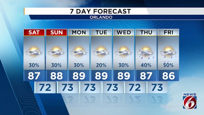

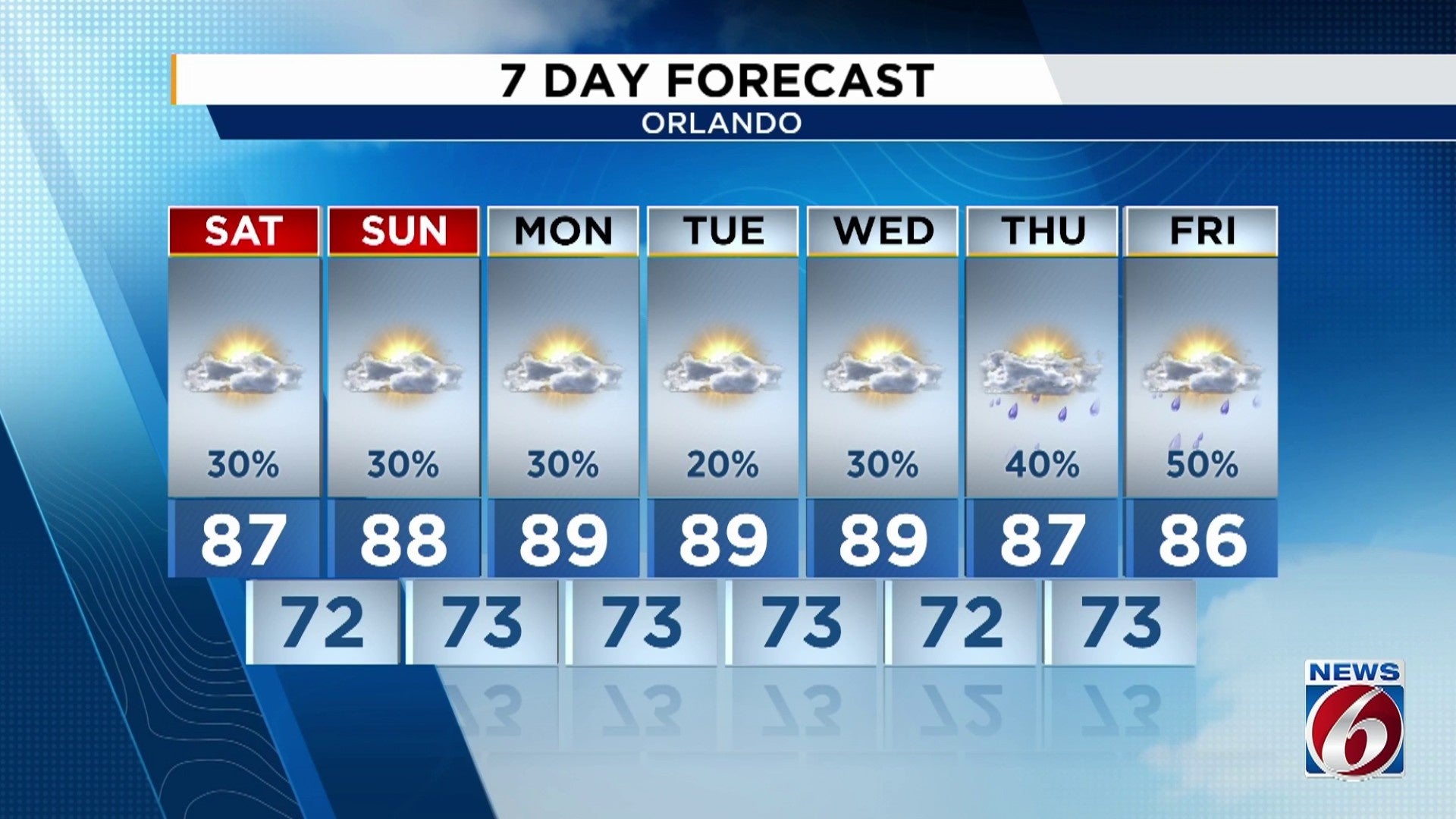
ORLANDO, Fla. – Many in Florida are enjoying the pleasant change brought by cooler temperatures and drier air that have taken over the region. These conditions are expected to last at least until the middle of the upcoming week.
Tonight, temperatures are predicted to dip into the low 70s for most areas, with some northern regions possibly experiencing readings in the upper 60s.
Have you noticed we’re slowly but surely getting back into the part of the calendar year where this is a more frequent occurrence?
I know I have, and I’m so here for it!
The mentioned dry air is also keeping rain chances minimal. However, the possibility of an isolated shower or rogue thunderstorm in the late afternoon or early evening cannot be completely ruled out, similar to recent occurrences.
But all-in-all, much of your upcoming Sunday, the second half of your weekend, is looking pretty stellar.
An upper-level low is positioned over northern Florida and a large part of the southeastern U.S., contributing to the influx of cooler, drier air from the north. This setup is maintaining a pathway for continued cooler air to move south into our vicinity.
If you’re seeking a break from rainy weather, this pattern provides it. Due to the positioning of the trough supporting the upper low at its southernmost point, our area lies in a calmer zone, away from more severe weather.
Just off our east coast, a weak and broad area of low pressure is forming. This is assuredly non-tropical. Although it’s the hurricane season’s peak, the familiar Atlantic activity hasn’t quite picked up yet.
The low pressure trying to develop off our immediate east coast is what’s going to drive the winds in from the north and east. This could provide us with just enough moisture to get a few showers and storms to flare up during tomorrow afternoon pushing inland from our east coast counties towards the Orlando metro area.
A lot of these clusters of showers will be pretty small in size, very localized instances of rain. The dry air well above us high in the atmosphere just won’t allow for any generous development of more widespread heavier rains.
In fact rain isn’t the main weather story in Florida these days, it’s actually the winds and the surf produced by the winds.
We currently have a high rip current risk across our east coast county beaches from the northern border of Florida all the way down the Boca Raton area.
So please keep this in mind, plan accordingly, and be safe if you venture to our east coast tomorrow to take advantage of your primarily clear Sunday.
Where do we go from here? Upper low’s have a tendency to over stay their welcome. Computer models don’t do a fantastic job of interpreting when it is they are most likely to start to make their retreat. It seems the pivotal point where our local weather pattern begins to change once again, will happen between late Wednesday and Thursday of this upcoming week.
We’ll likely start to see humidity building back in, as well as an increasing chance for extra rainfall. This is even more so the case if you reside in some of our southern counties, like Polk, Osceola, and Brevard.
The exit of our upper level low is critical in your week ahead. We’ll be working to iron out the details on its progression, and what may start to work its way in shortly thereafter.
[INSERT COPY HERE]
Copyright 2025 by WKMG ClickOrlando – All rights reserved.


