
SAVANNAH, Ga. — As the evening progresses, the showers and thunderstorms that have lingered in the region are expected to clear out, ushering in a wave of chilly air.
Earlier today, Southwestern Georgia experienced a slow start to storm activity. However, as a cold front advanced, storms eventually intensified, particularly affecting southern parts of the Coastal Empire. Fortunately, the most severe weather conditions remained south of this area.
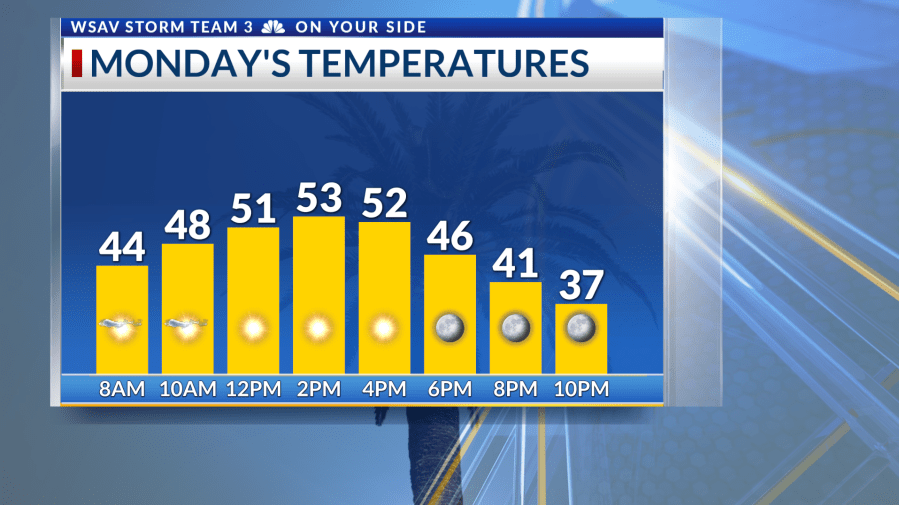
Monday is set to be brisk, with temperatures dipping into the 40s. A northwesterly wind will further enhance the chill, despite sunny skies. Even with the sun, temperatures will likely struggle to reach the 50s, maintaining a cold feel throughout the day. As the sun sets, expect temperatures to drop significantly, making for a cold evening for any outdoor activities.
A Freeze Warning has been issued from Monday night into Tuesday morning for much of the region. Meanwhile, other areas are under a Freeze Watch during the same period. Regardless, Tuesday morning will be frigid, with temperatures falling to between the upper 20s and lower 30s. Wind chills could make it feel like the upper teens to lower 20s.
Be sure to protect the four P’s: people, pets, plants, and pipes.
- People: dress warm, check on others, limit time outside
- Pets: bring them inside, provide warmth in outdoor shelter, check paws
- Pipes: insulate exposed outdoor pipes
- Plants: cover up outdoor plants, bring sensitive plants inside
While winds will gradually subside throughout Tuesday, the day will remain cold, with afternoon temperatures again peaking only in the 50s. As high pressure settles over the area, another cold night is expected, particularly west of I-95, where a widespread freeze is likely. By Wednesday, temperatures are predicted to climb into the 60s.
Temperatures moderate closer to average by the end of the week. Mornings will be in the 40s while 70s make a return for afternoon highs. Plenty of sunshine is anticipated and the workweek will be rain-free.