
Extensive areas of New South Wales are bracing for significant rainfall starting today, with advisories issued regarding potential storms and strong winds.
Comparable weather conditions are anticipated across southern inland Queensland, eastern Victoria, and the Australian Capital Territory.
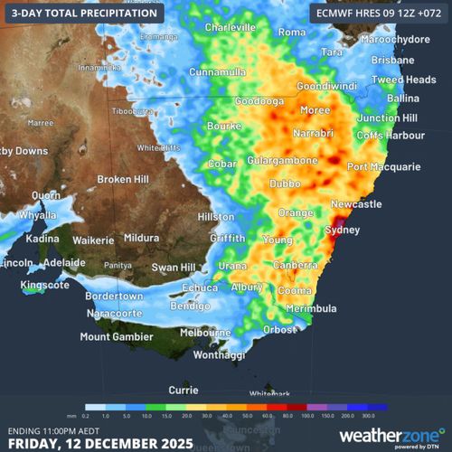
The Bureau of Meteorology has predicted an uptick in showers and thunderstorms primarily affecting the central NSW coast and northwest regions today. Rainfall could peak at 30mm to 50mm per hour, with localized 24-hour accumulations possibly reaching between 70mm and 120mm.
Areas such as the Hunter, Sydney, Illawarra, and parts of the northwest are likely to experience the heaviest downpour.
Although this rain is expected to ease the bushfire threat considerably, authorities caution residents about the likelihood of storm-related damage.
NSW SES Assistant Commissioner Nicole Hogan has highlighted concerns over the risk of falling branches from trees already weakened by previous fires.
“Trees that have been damaged by fire may be unstable and more likely to fall when it is windy and wet.
Motorists heading to Christmas holiday destinations are also being urged to take care on roads.
“Storms and localised heavy rain may also cause flash flooding due to increased runoff in locations that may not normally flood. If you come across a flooded road, turn around and find a safer route.”
The wet conditions are being driven by two low-pressure systems over inland and coastal NSW fed by moisture-filled winds from the Tasman and Coral seas.
Conditions are expected to ease by late tomorrow, before another bout of thunderstorms is predicted for many areas over the weekend, shifting to the north on Monday.
To stay up to date with the latest warnings and information, download the Hazards Near Me app or visit the NSW SES website.