
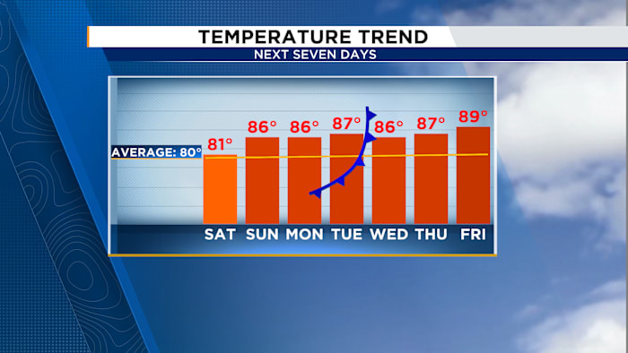
ORLANDO, FL – Central Florida basked in splendid weather as Orlando reached a pleasant 81°F. As Sunday approaches, temperatures are set to rise slightly, although the day might begin with patches of thick fog. Early risers are advised to proceed with caution on the roads.
After the fog dissipates, anticipate a delightful day with gentle breezes, abundant sunshine, and a refreshing drop in humidity. Temperatures will soar into the mid to upper 80s throughout the area, accompanied by westerly winds blowing at 5 to 15 mph.
As spring break draws to a close, those visiting the Atlantic beaches should remain vigilant, as high rip current risks continue. Waves ranging from 2 to 5 feet might also cause some minor beach erosion. To ensure safety, swimming near lifeguards is recommended.
Another factor to consider is the heightened fire risk. East central Florida will experience these conditions through Monday due to exceptionally low humidity levels.
Relative humidity denotes the amount of moisture present in the air compared to its maximum capacity.
Imagine the air functioning like a sponge:
-
If it’s holding a lot of water, the relative humidity is high (humid, sticky feeling)
-
If it’s holding very little water, the relative humidity is low (dry air)
Simple example:
-
100% humidity = the air is full of moisture
-
50% humidity = the air is holding about half of what it can
-
20% humidity = very dry air
In weather terms, low relative humidity dries things out quickly, which is why fire risk goes up when humidity is low.
While Lake County has lifted its burn ban, others remain in effect—Brevard and Polk counties still have restrictions, and in Orange County, burning yard debris is always prohibited.
What a burn ban means:
-
No outdoor burning, including campfires and bonfires
-
No burning of yard waste or debris
-
No unauthorized fireworks or open flames
-
Grilling is usually allowed but should be done with caution
-
Violations can result in fines or other penalties
Looking ahead to the workweek, the warm pattern sticks around. However, our next chance for rain arrives Tuesday into Wednesday as a front approaches and potentially stalling.
Expect breezy conditions with scattered showers, but temperatures will remain on the toasty side.
Copyright 2026 by WKMG ClickOrlando – All rights reserved.


