
The Bureau of Meteorology has issued a warning today as it monitors the progression of Tropical Cyclone Maila, which has intensified into a Category 3 storm. With winds sustaining speeds of 120 km/h and gusts reaching up to 165 km/h, the cyclone poses a significant threat to the region.
Australia has recently been battered by Tropical Cyclone Narelle. Last month, Narelle wreaked havoc across north Queensland, the Northern Territory, and Western Australia, leaving a trail of destruction in its wake as both a cyclone and its aftermath.
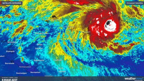
Currently, Tropical Cyclone Maila is lingering over the Solomon Sea, but forecasters predict it will start making its way toward the Far North Queensland coast later in the week. The possibility of it making landfall over the weekend is growing.
Communities still recovering from the damage and flooding caused by Narelle may once again find themselves in the path of fierce winds and torrential rains if Maila continues its predicted south-west trajectory.
This latest storm, Tropical Cyclone Maila, marks the 11th named cyclone to either develop in or enter the Australian region during this storm season.
Projections indicate Maila could escalate further to a severe intensity, maintaining its Category 3 status by late Sunday or early Monday, according to meteorological models.
“Should it cross the Cape York Peninsula, the system could weaken over land and then reintensify in the Gulf of Carpentaria, before impacting the eastern Top End early next week as it moves west,” Weatherzone said.
It’s too early to forecast whether Tropical Cyclone Maila will also impact Western Australia, forecasters say.
But they’re reminding Top End communities to be mindful that a weakened or redeveloped system could bring heavy downpours and to check for updates.
NEVER MISS A STORY: Get your breaking news and exclusive stories first by following us across all platforms.