
Tropical Storm Arthur has developed in the Gulf, becoming the first named storm of the 2026 Atlantic hurricane season.
The National Hurricane Center said Wednesday morning that Arthur had intensified into a tropical storm, packing maximum sustained winds of 40 mph.
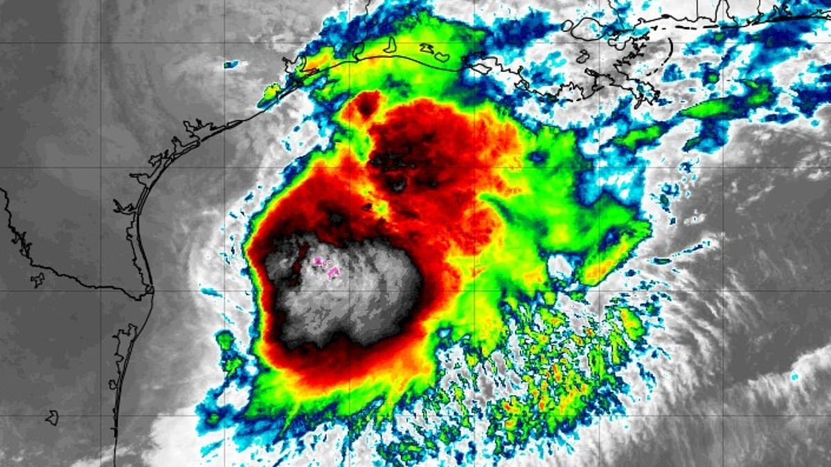
At the time of the update, the storm was centered about 40 miles northeast of Port O’Connor, Texas, and roughly 190 miles west-southwest of Lake Charles, Louisiana.
Forecasters say Arthur is expected to track northeast along the Texas coast before moving inland across southwestern Louisiana later Wednesday.
The storm is forecast to bring widespread rainfall of 5 to 10 inches through early Friday, with some isolated spots potentially seeing close to 20 inches. The National Hurricane Center cautioned that the downpours could trigger dangerous, potentially life-threatening flash flooding.
The most intense rainfall is expected to stretch from the middle and upper Texas coast across Louisiana, Mississippi and Alabama, with impacts also reaching western Georgia and the Florida Panhandle.
Forecasters warned of storm surge flooding of two to four feet above ground level from Port Bolivar, Texas, to Morgan City, Louisiana.
Swells generated by Arthur are also expected to create life-threatening surf and rip current conditions along portions of the northwestern Gulf Coast during the next several days.
The National Hurricane Center (NHC) announced Wednesday morning that Arthur had strengthened into a tropical storm with maximum sustained winds of 40mph
The National Weather Service (NWS) said in a Wednesday morning alert: ‘Efforts to protect property should now be underway.
‘Prepare for limited wind damage. Act now to complete preparations before the wind becomes hazardous.
‘Storm surge flooding preparations should be underway. Assemble disaster supplies and know your evacuation route.’
Tropical Storm Warnings stretched from High Island, Texas, to Morgan City, Louisiana, where forecasters said tropical storm conditions were expected within the next 12 hours.
A Tropical Storm Watch remained in effect from Sargent to High Island, Texas, meaning tropical storm conditions were possible in those areas during the same period.
Offshore waters are expected to experience hazardous conditions, with winds exceeding 46mph and seas building to as high as 11 feet.
The NWS warned that major flooding could trigger evacuations and water rescues, overwhelm rivers and drainage systems and leave roads and bridges impassable.
Streets and parking lots could quickly become flooded, creating hazardous travel conditions.
According to the NHC, Arthur will continue moving northeast along the Texas coast before pushing inland across southwestern Louisiana by this evening

Arthur is expected to produce widespread rainfall totals of five to ten inches through early Friday, with isolated areas receiving nearly 20 inches, potentially creating life-threatening flooding
National Hurricane Center director Michael Brennan said during a briefing that flash flood warnings have been issued in the Houston metro area, with more likely to follow across the region, even after the center of the storm passes.
‘The main threat from Arthur is going to be a prolonged, multiday, heavy rainfall event that could produce dangerous to life-threatening flash flooding,’ Brennan said.
Houston is set to host Wednesday’s World Cup clash between Portugal and the Democratic Republic of the Congo.
The match is expected to go ahead as scheduled, with the city’s covered stadium shielding fans and players from the storm.