

ORLANDO, Fla. – Rain chances across Central Florida continue to ease as high pressure strengthens in the upper levels of the atmosphere and another plume of Saharan dust moves over the state. The pattern is expected to hold into the weekend, bringing hotter temperatures and fewer widespread storms.
This Weekend
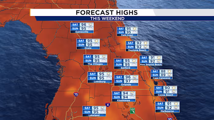
A fresh surge of Saharan dust will help keep storm coverage more limited this weekend while also allowing afternoon temperatures to climb. Rain chances will not disappear entirely, but they are expected to drop to around 30% to 40%, mainly along the afternoon sea breeze.
With upper-level ridging in place and dust reducing storm development, highs are forecast to reach the mid- to upper 90s. When humidity is factored in, heat index values will likely rise above 100 degrees, putting parts of the area close to heat advisory levels.
Next Week
The forecast begins to shift early next week as winds change and moisture increases. A weakening frontal boundary is expected to move toward North Florida, bringing additional moisture and atmospheric energy. That setup should help return winds to a more typical easterly flow, supporting more widespread sea breeze showers and storms and pushing the sea breeze farther inland. The highest rain chances will focus along the I-4 corridor and areas to the west, with coverage rising to 60% to 70%.