

BAYOU LA BATRE, Ala. – Isaias intensified into a powerful Category 3 hurricane Friday as it raced toward the U.S. Gulf Coast.
The storm’s maximum sustained winds climbed to 120 mph (193 kph), the Miami-based National Hurricane Center said. That pushed Isaias beyond the 111 mph (179 kph) threshold for Category 3 status, the level at which a hurricane is classified as major.
As the first hurricane of the Atlantic season approached land, forecasters warned that conditions could deteriorate rapidly across the Florida Panhandle, southern Alabama and southern Mississippi. Isaias was expected to make landfall late Friday, with heavy rain and flooding potentially reaching Tennessee and North Carolina through the weekend.
THIS IS A BREAKING NEWS UPDATE. Check back for updates. AP’s earlier story follows below.
Earlier Friday, Isaias was forecast to become a major hurricane as it advanced toward the Gulf Coast, where residents and emergency crews were completing preparations for potentially deadly storm surge and hurricane-force winds.
The National Hurricane Center projected that the storm would come ashore late Friday near the Alabama-Florida border, bringing hazardous conditions to the Florida Panhandle, southern Alabama and southern Mississippi.
Isaias was a Category 2 hurricane early Friday, with winds reaching 110 mph (177 kph), just below the Category 3 benchmark. Forecasters expected additional strengthening and warned that a Category 3 hurricane can inflict devastating damage.
The storm was expected to lose strength quickly after moving ashore, falling to tropical-storm status by Saturday afternoon as it tracked northward inland along the Alabama-Mississippi border, according to the hurricane center.
“Preparations should be rushed to completion as the weather will go downhill quickly today,” the hurricane center said in an early-morning forecast. Although Isaias was not expected to reach land at its peak strength, forecasters said it would likely remain a significant hurricane when it reached the coast.
Isaias, the Atlantic season’s first hurricane, was located roughly 200 miles (322 kilometers) south-southeast of the Mississippi River mouth and moving north at approximately 15 mph (24 kph), the center reported.
Forecasters expected the hurricane to reach the coast during the evening between Mobile Bay in Alabama and Choctawhatchee Bay in the Florida Panhandle.
In addition to powerful winds and storm surge, Isaias threatened to produce flash flooding and tornadoes, the hurricane center warned.
A hurricane warning stretched from Ocean Springs, Mississippi, across the western Florida Panhandle. Tropical storm warnings covered an area from southeastern Louisiana to the Aucilla River along Florida’s Big Bend.
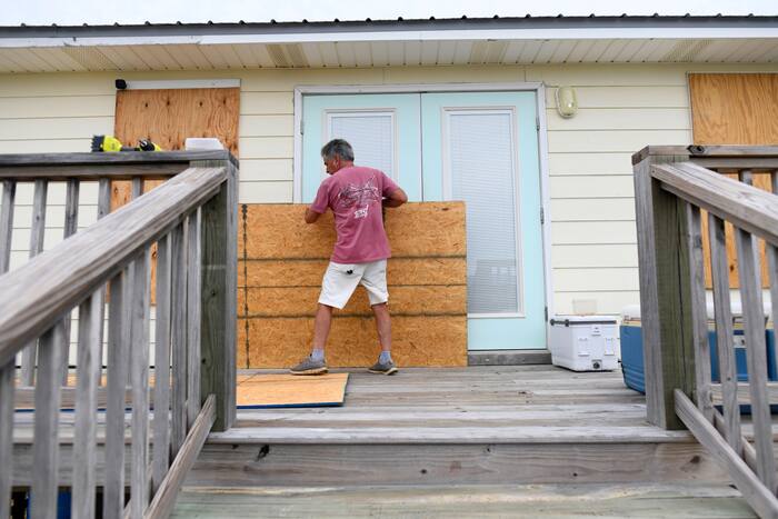
Communities had been preparing for the storm for several days. Residents boarded up homes and filled sandbags Thursday, while thousands of National Guard troops were deployed across the region.
The hurricane center forecast a storm surge of 5 to 7 feet (1.5 to 2 meters), with the highest water levels expected along the immediate coast. Large, dangerous waves were also likely.
Alabama Gov. Kay Ivey ordered non-residents to leave Gulf Shores, Orange Beach and Dauphin Island as coastal communities accelerated their preparations Thursday. Social media videos showed traffic at a standstill on the highway leaving Gulf Shores, where double-red flags indicated that beaches and water access had been closed.
Several counties ordered evacuations in vulnerable coastal areas. The governors of Florida and Alabama declared states of emergency across dozens of counties, while Florida Gov. Ron DeSantis said about 5,000 National Guard troops were expected to mobilize by Friday.
Officials on Dauphin Island, a 15-mile (24-kilometer) barrier island off Alabama, urged residents to consider voluntary evacuations. The island’s western end, a popular destination, was considered especially exposed to storm surge.
Mayor Jeff Collier said he was not expecting extensive damage but emphasized the storm’s unpredictability. “A little jog here or there, or some last-minute increase in strength — we just have to be prepared for the worst,” he said.
In the Pacific, Hurricane Simon was also gaining strength. The system formed as a tropical storm off Mexico on Wednesday, became a hurricane late Thursday and was forecast to intensify into a Category 4 storm.
___
Rico reported from Atlanta and Collins reported from Hartford, Connecticut. Also contributing were Associated Press reporters Kim Chandler in Montgomery, Alabama; Hallie Golden in Seattle; Kathy McCormack in Concord, New Hampshire; John Raby in Charleston, West Virginia; Laura Turbay in Little Rock, Arkansas; and Julie Walker in New York.


