
Share this @internewscast.com

ORLANDO, Fla. – As soon as August began, the weather action kicked into high gear. We’ve already encountered another named storm, and we’re currently monitoring two potential systems in the process of development.
One of which has shown up in a VERY familiar spot.
Do you recall Tropical Storm Chantal? Although it wasn’t a direct threat to Florida, it quickly formed nearby and made landfall in the Carolinas, bringing them heavy rain and flooding, much like Barry did earlier in central Texas.
We also had two different iterations of Invest 93L, in the exact same spot.
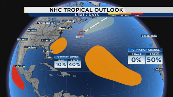
Take a look at the National Hurricane Center’s outlook.
In the latest update at 8 a.m., the risk level has increased from yellow to orange, indicating a 10% possibility of tropical development within the next two days, rising to 40% over the next week. I anticipate these probabilities will continue to increase throughout Tuesday, with a potential early sign of system formation by Thursday.
There’s more involved here than just the potential for a new named storm. From a forecasting standpoint, we need to consider a crucial detail that might influence developments as we approach the peak of hurricane season.
What are the odds something new forms?
Before delving deeper, let’s discuss the likelihood of a new tropical storm forming near our northeast. Model projections are quite certain about a low-pressure area emerging in the next three to four days. It’s highly probable that, if not by later Tuesday, we’ll see the NHC percentage predictions increase.
Even our internal computer models suggest some activity could start off the east or northeast coast of Florida before hopefully veering away. Some forecast models even suggest it might stay completely offshore, as Dexter did.
But we also have rebuilding high pressure both in the wake of Dexter to the north and back across the western Atlantic ocean, attempting to push back westward over us again.
This would act to give this circulation a little nudge, like someone elbowing you while sitting beside you, kicking it back toward either the southeast or mid-Atlantic U.S.
Ensemble probabilities for formation are amped at the moment, coming in close to 90% chance at least a tropical depression develops. The “ceiling,” or the strongest potential end game for a system like this, is a tropical storm. This would be a repeat of what we observed during Chantal’s development and lifecycle.
Now, here’s the kicker …
WHY do we keep getting features to randomly spin up off our coastline? It has a lot to do with the heat wave, if not several heat waves Central Florida has had to fight through the last couple of months.
We’ve essentially focused a lot of the instability, lift and heat close to home. This was a concern earlier in the year of ours as well. Now we’ve made matters a tad worse with stubborn high pressure ridging keeping our rain chances on and off but stopping temperatures from sinking below the mid to upper 90s.
In the short-term, we’re already seeing what this region of more than favorable conditions can do. In the long-term, it bears monitoring especially once we hit the fall.
Even within the next seven to 10 days, our next area of interest in the Atlantic has an option to try and move westward closer to the mainland U.S. If it does, a few of our global computer models show a slow to organize process before wandering into this area of greatly charged up water temperatures.
We’ll need to watch this as we go through August and September.
Late September and especially October, even more so in my opinion (as we tend to see a return to these close-to-home, homegrown features coming off the U.S.) as stronger cold fronts start coming down during the switch from summer to fall.
In October, the Central American Gyre tends to make a return, which has created some VERY notorious hurricanes Floridians are incredibly familiar with (Helene, Michael, and Milton to name a few).
Copyright 2025 by WKMG ClickOrlando – All rights reserved.