
Share this @internewscast.com
TAMPA, Fla. (WFLA) — We’re over two months into Hurricane Season, and after a quiet start, there might be something brewing in the Atlantic.
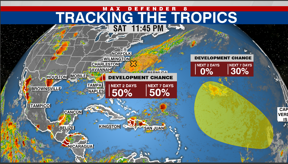
The National Hurricane Center is keeping an eye on two disturbances: one is near the Carolinas and is currently moving away from the coast, while the other is much farther out in the Atlantic and heading toward the East Coast.

As of 8 a.m. Sunday, the first disturbance was positioned 180 miles away from the North Carolina shoreline, bringing along some rain showers and thunderstorms. The atmospheric conditions are somewhat conducive to the disturbance potentially developing into a tropical depression either today or by Monday. This disturbance is traveling east-northeast at roughly 10 mph, away from the land.
The NHC gave Disturbance 1 a 50% chance of formation over the next 48 hours and a 50% chance over the next 7 days.
The second disturbance is located further in the Atlantic, closer to the Lesser Antilles, classified by the NHC as a “tropical wave” originating from the western coast of Africa.
In the next 48 hours, there is no chance of this one forming a cyclone, but conditions in the following week could support a gradual evolution into a cyclone as it progresses west-northwest. Within the next seven days, the possibility of development is around 30%.
Watch Tracking the Tropics on Tuesdays at 12:30 p.m. ET/11:30 a.m. CT
Stay informed by tuning into Spotify or Apple Podcasts. Prepare yourself with the 2025 Hurricane Guide and stay updated on tropical developments with the Tracking the Tropics newsletter.