Share this @internewscast.com
ORLANDO, Fla. – Central Florida is set to experience a dramatic weather shift as a robust cold front is expected to arrive early Monday evening.
The likelihood of rain is minimal, with just a slight chance of a quick sprinkle or passing shower accompanying the front’s passage.
Before the front arrives, temperatures in the Orlando region are predicted to remain unseasonably warm, reaching highs in the upper 70s.
[VIDEO BELOW: Florida cities with Winter year-round]
Despite the inviting weather, beachgoers should exercise caution due to a high risk of powerful and potentially life-threatening rip currents along the Atlantic shoreline. While boating conditions appear favorable, a Small Craft Advisory will take effect Monday night as winds are expected to intensify.
As Monday night unfolds, significantly cooler air will sweep in, causing temperatures to plummet sharply late in the evening.
Neighborhoods northwest of I-4 will feel the chill early, where temperatures could dip into the upper 30s.
Many inland areas will fall into the low to mid 40s, with 50s closer to the coast.
Gusty northwest winds behind the front will make it feel even colder, with wind chills near sunrise falling into the 30s across northern and western areas and into the 40s farther south.
Tuesday
Tuesday will remain breezy and much cooler, with highs near 60 degrees north of Interstate 4 and in the low to mid-60s to the south.
Tuesday night is shaping up to be the coldest night of the week.
Overnight temperatures in the 30s are expected across much of the area, with a few inland locations potentially dropping into the lower 30s for a short time.
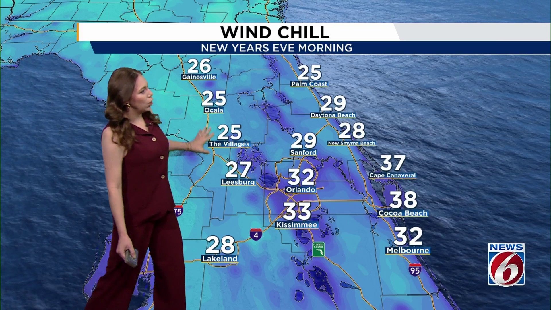
Wind chills late Tuesday night into Wednesday morning could fall into the upper 20s to low 30s across most of Central Florida, which is why a Cold Weather Advisory or even a Freeze Watch may be needed.
New Year’s Outlook
The remainder of the week stays mostly dry as cooler and drier air remains in place.
High temperatures will stay in the 60s through the end of 2025 before gradually warming into the low 70s by Friday.
By the time the clock strikes midnight to ring in 2026. temperatures will be dropping quickly, especially inland, with many areas in the 40s and some upper 30s away from the coast.
A light breeze will add an extra chill for anyone celebrating outdoors, so jackets and layers will be needed if you plan to be outside as 2026 begins.
A slow warming trend continues into early next week, with highs returning to the 70s and milder overnight conditions by Saturday and Sunday.
Copyright 2025 by WKMG ClickOrlando – All rights reserved.