
Share this @internewscast.com
ORLANDO, Fla. – I hope your Christmas was both joyous and memorable. With the delightful weather we’re experiencing, there’s every reason to keep the celebrations going!
Before diving into the weather details, I genuinely hope you and your loved ones enjoyed a wonderful holiday season.
As we stand on the brink of 2026, it’s a time for reflection and resolution-making here in Central Florida.
Just as we set our personal goals for the upcoming year, Mother Nature seems to have her own plans. She’s preparing to usher in the winter season with a notable chill, perfectly timed for New Year’s Eve.
While we’ve been enjoying above-average temperatures during the day and comfortable mornings and evenings, brace yourself for a stark change. By Monday night and into Tuesday, it will feel as though you’ve accidentally left the freezer open overnight.
A significant storm system is currently on the move. As it progresses eastward across the northern United States, it’s poised to pull down a blast of cold Canadian air, potentially bringing near-freezing or even freezing conditions our way.
Before I give you a brief play-by-play of what that looks like, Sunday and Monday should continue to hold these warm and quality weather conditions around for a little while longer.
High pressure sets right off our Gulf coast. When you look at the current wind flow around our region, it’s almost like you could reach out and touch the center of high pressure if you were a western Floridian.
Because we’re so close to the focused sinking air within higher pressure systems, moisture is also trapped close to us at ground level. Winds are rather calm, which means we could wake up tomorrow and Monday morning’s in some fairly dense fog.
Most computer models suggest we’ve got abundant moisture squished down within the first 100 feet of our atmosphere if you think about it three-dimensionally. With a lack of potent wind speeds that moisture is likely to take on the form of clouds at the surface – fog.
So be mindful of this is you plan to hit the road or step out for a morning workout before church, breakfast, or prepping brunch tomorrow and Monday while the kids are still on their winter break.
This will burn off shortly after the sun comes up though, and we’ll be back in a mix of clouds and sunshine with afternoon high’s touching the upper 70s. We’ll try to see a few 80s out there across Central Florida, before we come crashing down late Monday night and through Tuesday morning.
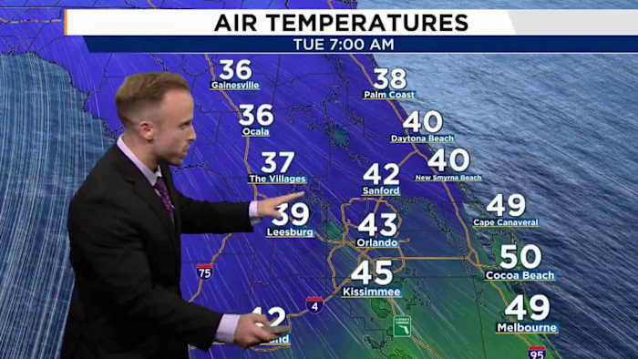
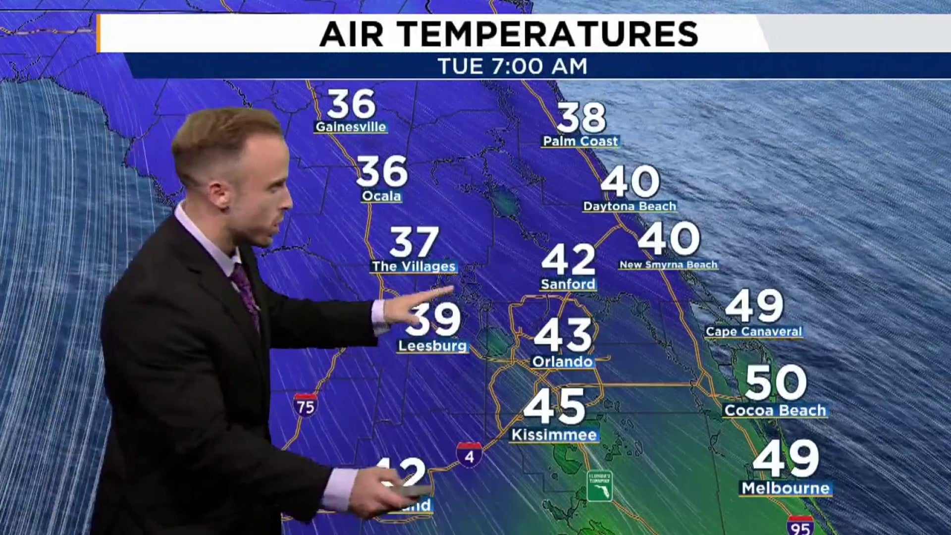
The cold front is expected to reach us and swing through late in the evening on Monday night with temperatures absolutely tumbling cliffside as we approach sunrise Tuesday morning.
The coldest weather settles in with us by Wednesday morning, where a number of our morning low temps could be hovering between the upper 20s and low-mid 30s from our northern counties back down across the Orlando metro area.
Given this is such a dense slug of cold air, and we’ve got lots of warmth out in front of it, the air will be moving pretty fast as well. Wind speeds will pick up both ahead of the front and back behind it for an extended window, bringing feels like temps well into freezing territory.
Northern Central Floridians should be prepped for extreme wind chill, and feels like temps in the mid 20s through areas of Alachua, Marion, and upper Lake/Sumter counties. Orlando, and those of us in Polk, Osceola, Brevard will also feel like the 30s for Wednesday morning especially.
These cold temperatures will be with us through the New Year, so absolutely take this into account as you button up for the celebrations and plan your holiday occasion. If you plan to be outdoors, you might want to carry an extra layer or two if you can. Or maybe move the shenanigans indoors if you want to show off the outfit of the evening.
Copyright 2025 by WKMG ClickOrlando – All rights reserved.