
Share this @internewscast.com

ORLANDO, Fla. – Central Florida is poised for a shift in weather patterns, ushering in a blend of clouds, intermittent showers, and increased temperatures.
Wednesday
The day will be predominantly overcast due to moisture moving inland from the Atlantic. A brisk onshore breeze may bring sporadic rain along the coastal regions. Temperatures are expected to climb to the mid to upper 70s, slightly above the seasonal average. The night will remain comfortably mild, with temperatures dipping only to the low to mid-60s.
[VIDEO BELOW: Are Walmart drone deliveries coming soon?]
Thursday
Rain becomes more likely as a cold front advances toward the region. There is a 30-40% probability of scattered showers, with isolated thunderstorms possibly forming later in the afternoon and evening.
While widespread severe weather is not expected, any storm that forms could produce lightning, gusty winds and brief heavy downpours.
Temperatures remain warm ahead of the front, with highs in the upper 70s.
Friday
We will start with lingering showers early but improving conditions as the front moves through later in the day. Once the front passes, cooler and drier air moves in Friday night. Overnight lows will drop into the 50s.
[VIDEO BELOW: Angel Tree helps families in need]
Weekend
The weekend into early next week looks quieter. High pressure builds in quickly, bringing drier air and more stable conditions.
Most of the time, it will be dry, although an isolated onshore shower cannot be ruled out as moisture slowly returns.
Temperatures will remain comfortable, with daytime highs mostly in the 70s and a few locations touching the low 80s on Sunday.
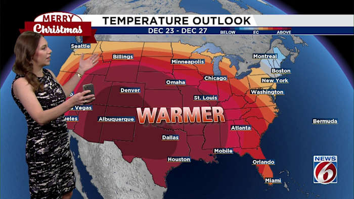
Christmas Preview
Looking ahead to Christmas, the forecast is shaping up to stay on the mild side, with no major changes.
Current trends show relatively quiet weather for a large portion of the country as well, which should be good for those planning on traveling during the holidays.
Copyright 2025 by WKMG ClickOrlando – All rights reserved.