
Share this @internewscast.com

ORLANDO, Fla. – I hope your Sunday has been absolutely wonderful! Currently, we are enjoying plenty of sunshine, some clouds to give us shade, and the typical Florida humidity remains present.
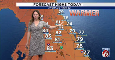
Dry air has limited rainfall for most areas, with just a few patches of light rain impacting our east coast counties. As the day heats up into the early evening, some isolated showers might develop in our interior regions, particularly in Seminole, Orange, Osceola, and Polk counties.
Northeast winds shifting southwest are pushing what moisture is in the atmosphere towards the Gulf coast at a swift pace.
These winds also create challenging surf conditions along our Atlantic coast. Rip currents remain a concern due to the high-pressure system to our north, which is bringing gusty winds against the shore.
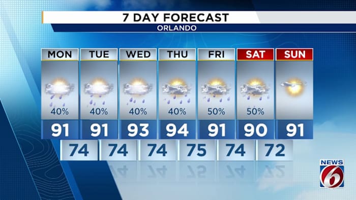
As we head into Monday, we expect some changes. The high pressure will begin to move away, allowing tropical moisture from the south to move in.
Rain chances will slightly increase tomorrow, but it shouldn’t affect your plans significantly for the day. However, by Tuesday afternoon, the weather could become wetter, possibly affecting your afternoon commute.
You won’t need the rain gear tonight or tomorrow. You’ll still want to dress appropriately for all the mugginess in the air though, as one thing is for certain – humidity values refuse to fall at all despite FALL officially commencing per the calendar tomorrow.
Yes, tomorrow is indeed the first day of Fall for all of us across the country. For Central Florida however, we’ll need to wait our turn before we partake.
Even with an approaching cold front late in the week and next weekend, temperatures are expected to mingle around the upper 80s, with a few spots seeing 90 degrees during the mid afternoon.
Dry air will make a return though, and once the front has moved on rain chances will diminish once again. We’re starting to reach the point in the year where this becomes our primary source for any daytime or even overnight rains.
As we move away from summer, the afternoon sea breeze will become a thing of the past and we’ll have to rely on cold fronts or even tropical features to produce rainfall keeping our lawns and gardens fresh without tapping into our sprinklers.
I also want to note NOAA is forecasting a dip into La Nina conditions for the Pacific. If we do realize this prediction, that could make for a drier and slightly more mild winter for us Floridians as we approach the holiday season. But we’ll cross that bridge when we get there.
For now, enjoy your Sunday and kick off Monday on a high note as we continue this lack of rainfall. Then into Tuesday, humidity will crank up even more so with the return of maritime tropical air and showers increasing in the forecast.
Copyright 2025 by WKMG ClickOrlando – All rights reserved.