
Share this @internewscast.com
TAMPA, Fla. (WFLA) — Hurricane Erin has moved back into the sea after delivering substantial rain and creating perilous rip currents in the Caribbean and along portions of the East Coast.
As of 8 a.m. on Saturday, there are no tropical storm watches or warnings in the Atlantic, though that may change by the end of the day.

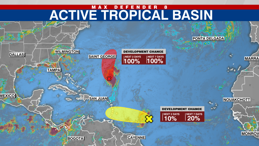
Experts at the National Hurricane Center are observing an area of low pressure roughly 500 miles to the southeast of Bermuda. They anticipate this will likely evolve into a tropical depression by Saturday and may strengthen into a tropical storm by Sunday as the low-pressure system travels northward.
Chances of development are high, at 100%, for both the next 48 hours and seven days, though it’s not expected to affect the U.S.
The NHC is also tracking a tropical wave emerging from the east coast of Africa. Such a wave is a disorderly low-pressure region that results in rain and thunderstorms, with the potential to develop into a tropical depression.
This wave is situated approximately 850 miles east of the Caribbean Islands and is advancing westward across the Atlantic at a speed of 20 mph. There is potential for development over the coming days, which could lead to intense rain and strong winds impacting parts of the Windward Islands. These islands form the southern segment of the Lesser Antilles, typically including Dominica, Martinique, St. Lucia, St. Vincent and the Grenadines, Grenada, Barbados, and Trinidad and Tobago.
Development chances are low at 10% over the next 48 hours and 20% through the next seven days.
Watch Tracking the Tropics on Tuesdays at 12:30 p.m. ET/11:30 a.m. CT
For more insights, tune into Spotify or Apple Podcasts. Equip yourself with the 2025 Hurricane Guide and keep informed about tropical activity with the Tracking the Tropics newsletter.