
Internewscast Journal
  • Home
  • US News
  • Local News
  • Health
  • People
  • Guest Post
  • Support Our Cause
Internewscast Journal
  • Home
  • US News
  • Local News
  • Health
  • People
  • Guest Post
  • Support Our Cause
Home Local news Increased Chances for Tropical Development off Florida’s Gulf Coast: Key Details
  • Local news

Increased Chances for Tropical Development off Florida’s Gulf Coast: Key Details

  • 3 minute read
Total
0
Shares
Share 0
Tweet 0
Pin it 0
Tropical development looking more possible off Florida’s Gulf Coast. Everything to know

Up next

Top Ukrainian spy gunned down in Kyiv ambush attack: report

Ukraine Reports Killing Russian Agents Linked to Senior Officer’s Ambush and Death

Published on 13 July 2025

Author

Internewscast

Share article

The post has been shared by 0 people.
Facebook 0
X (Twitter) 0
Pinterest 0
Mail 0

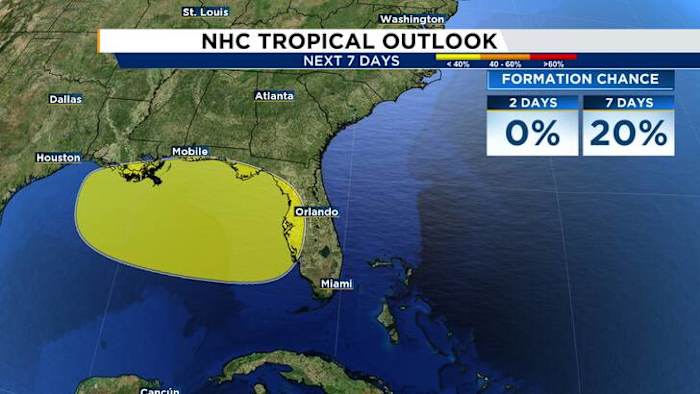
ORLANDO, Fla. – The National Hurricane Center has again identified a new area of interest right over Florida. Interestingly, it resembles the same pattern we noted prior to the formation of Tropical Storm Chantal near our northeast coast.

But in this case, we’re going the opposite direction.

Forecast models are honing in on the possible development of a low-pressure system off our east coast. This system is expected to move across Central Florida and potentially evolve into a tropical system over our Gulf Coast.

The spot to watch is currently off our east coast… again. But this time around, it’ll be drawn westward over Florida and into the eastern Gulf.

Recent data suggests some consensus among models that a tropical depression could develop as the system moves away from Florida, likely heading toward Louisiana at this point.

In terms of impacts to Central Florida, we’re looking at a mixed bag sort of scenario.

Satellite imagery of the area we’re monitoring as of Sunday morning looks fairly healthy and robust. This is precisely what helped generate Chantal a little quicker than even computer models suggested.

On infrared satellite this morning, we’re already seeing a good amount of storms popping near the area of leftover energy that could try to form into our next named system.

If thunderstorms continue to fire near the area of energy that’s being tracked, the National Hurricane Center could highlight this as our next invest area and push recon aircraft into the feature to start gathering more high resolution data.

Global computer models, ones we’re very familiar with – like the GFS or the Euro – are lower resolution than the hurricane models implemented by NOAA and NHC. Resolution means how large or how small of weather features they can “model” for us to build forecasts.

The GFS and the Euro can model low pressure areas well, but they struggle with smaller scale weather players like these fragments of energy that can sometimes plop off the U.S. coast into warm, open water. Simply put; they can model the state of Florida but not quite well your county, city, street, etc.

We noticed this trend a lot before Barry and Chantal developed. The lower resolution models seemed to indicate a weak, broad spin. The moment hurricane hunters started to investigate the systems and pull in the data from within, we saw some large adjustments made.

Our next name on the list is Dexter, and there’s a fairly decent shot we see our next named storm somewhere in the eastern Gulf. Thankfully, the general idea is it tracks away from us Floridians but unfortunately puts the central Gulf coast in its crosshairs.

Rain chances this week

We could see some fairly gusty winds, especially closer to the east coast of Florida before it works its way over us. Coastal conditions could be fairly hostile, so definitely do some careful thinking if you want to hit the beach.

Rainfall totals look pretty impressive, especially for the Orlando metro area and the further south you go. Drought conditions are lingering for some of us in Central Florida, with even greater areas of south Florida still battling the dry season effects.

Currently it appears we could see anywhere between 2-4 inches of additional rainfall piling up on top of our afternoon thunderstorms we’ve repetitively observed.

Be on watch for roadway ponding, and some urban flooding as a result of your heavier downpours. This will also hit your commute hard, especially if your area in particular is dealing with the rougher weather between today and about Wednesday.

What this area of disturbed weather does as it transits out of the westernmost Atlantic and into the Gulf will tell us plenty of what to expect after it emerges back over open water.

Right now, I fully see a tropical storm trying to develop. We’ll have to give it another 18 to 24 hours and assess what this spot looks like as it moves in to Central Florida.

Copyright 2025 by WKMG ClickOrlando – All rights reserved.

You May Also Like

Scattered Sunday storms and sweltering high temperatures
  • Local news

Sunday Weather Forecast: Scattered Storms Bring Little Relief From Sweltering Heat

Thunderstorms once again pushing from west to east. Scattered afternoon thunderstorms expected…
  • Internewscast
  • July 5, 2026
Coco Gauff of the United States reacts after winning against Belinda Bencic of Switzerland in their fourth round women's singles match at the Wimbledon Tennis Championships in London, Sunday, July 5, 2026. (AP Photo/Kin Cheung)
  • Local news

Coco Gauff’s Last-Gasp Wimbledon Winner Brings Kawhi Leonard’s Iconic Shot to Mind

LONDON (AP) — Tennis does not typically come with a visible countdown…
  • Internewscast
  • July 6, 2026
Stormy start to the work week before a hotter, drier shift
  • Local news

Stormy Week Begins Before Hotter, Drier Weather Moves In

Temperatures expected in the mid-upper 90s by week’s end. Scattered storms expected…
  • Internewscast
  • July 6, 2026
As war grinds on, Ukrainian climbers build a new outdoor culture inspired by Yosemite
  • Local news

Ukrainian Climbers Forge Yosemite-Inspired Outdoor Culture Amid Ongoing War

DENYSHI – Perched above a river on a sheer granite bluff roughly…
  • Internewscast
  • July 5, 2026
St. Pete hosts ‘The Fourth’ to celebrate America’s 250th anniversary
  • Local news

St. Pete Plans The Fourth Celebration for America’s 250th Anniversary

ST. PETERSBURG, Fla. (WLFA) — Fireworks filled the sky over St. Pete…
  • Internewscast
  • July 5, 2026
Air quality alerts in and around D.C. warn of
  • US

D.C. Air Quality Alert: Pollution Warnings Issued Across the Washington Region

Air quality across Washington, D.C., and nearby communities fell sharply on Sunday,…
  • Internewscast
  • July 6, 2026
Pilot declares mayday before seaplane comes down in New York City’s East River
  • US

Pilot Issues Mayday Moments Before Seaplane Crash-Lands in NYC’s East River

Eight people were safely rescued Sunday afternoon after a seaplane made a…
  • Internewscast
  • July 6, 2026
WWII US airman's remains found 80 years later in Thailand
  • US

Remains of WWII US Airman Discovered in Thailand After 80 Years

Decades later, his story is a reminder of a solemn military promise:…
  • Internewscast
  • July 6, 2026
JSO: Woman arrested after shooting, killing man on Jacksonville's Northside
  • US

Woman Arrested After Man Fatally Shot on Jacksonville’s Northside, JSO Says

The Jacksonville Sheriff’s Office said the shooting followed an altercation between a…
  • Internewscast
  • July 6, 2026

Internewscast Journal

  • Home
  • Privacy Policy
  • DMCA Notice
  • Terms and Conditions
  • Guest Post
  • Support Our Cause
Copyright 2026. All Right Reserverd.