
Share this @internewscast.com

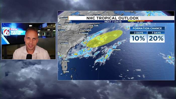
ORLANDO, Fla. – According to the National Hurricane Center’s 8 a.m. advisory, a new area of interest has been marked just off the eastern coast of North Carolina, indicating a low possibility for tropical development in the upcoming week.
This notice relates to the frontal system gradually moving into our southeastern region, which is expected to increase the likelihood of rain throughout the week.
The good news immediately – this will be no threat to Central Florida and is likely to continue on an eastward path away from any major landmass.
Forecast models have shown intriguing developments near the mid-Atlantic coast. Essentially, a low-pressure zone is anticipated to form, possibly along the frontal boundary, before it attempts to evolve independently into a rotating system.
These scenarios often lead to locally generated storms, known as homegrown storms. More detailed articles on this topic are available on our website if you’re interested in learning more.
[MORE: End in sight as summer heat dome persists. But there is a twist]
The next storm name on the list is Dexter, and we might nab another name from the list as we shift our focus towards the tropical Atlantic.
Looking past the first week of August, attention may turn towards the deep tropics near Africa’s coast for potential development. Robust tropical waves are expected to pass through the Atlantic’s main development area, with chances to evolve into more significant systems as conditions potentially become favorable.
Stick with News 6 for all your tropical weather information, especially as we start the climb into the peak of our 2025 hurricane season.
Copyright 2025 by WKMG ClickOrlando – All rights reserved.