
Share this @internewscast.com

The Storm Team 11 Forecast calls for a mild start to our weekend. There will be a 30% chance of scattered showers by late afternoon and evening. The high will be 78 degrees.
Tonight will be mostly cloudy with scattered showers late. The low will be 56 degrees. The rain chance will be 50%.
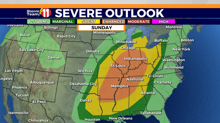
Scattered showers and thunderstorms are likely on Sunday with several rounds possible. The high will be around 72 degrees with a 60% rain chance.
Scattered showers and maybe a few thunderstorms will be possible overnight Sunday into Monday. The low will be a mild 58 degrees with a 40% rain chance.
Rain and thunderstorms are likely Monday morning and afternoon under mostly cloudy skies. The high will be around 72 degrees.
A few of those thunderstorms could be strong to severe. The primary threat is damaging winds up to 60 mph. Although the threat of isolated tornadoes and small hail is much less, it is NOT zero. The line will need to be monitored as it moves through around daybreak Monday.
Scattered showers and even a few non-severe thunderstorms will be possible through the late afternoon. Scattered showers will continue Monday night with a low of 43 degrees.
Tuesday will be cooler and mostly cloudy behind the departing system. The high will be 64 degrees with a 20% rain chance. Partly cloudy skies are forecast for Tuesday night. The low will be 45 degrees.
Wednesday, the highs will recover a bit to around 70 degrees with a 40% chance of scattered showers. Showers and a few thunderstorms will be possible early Wednesday evening. Showers will continue overnight at times. The low will be 58 degrees.
Thursday, more scattered showers and thunderstorms are likely throughout the day. The chance of rain will be 50% with a high of 75 degrees.
Unsettled weather will continue into next Friday with a 50% chance of additional scattered showers and thunderstorms. The high will be 77 degrees.
Enjoy the rest of this mild Saturday morning.