
Share this @internewscast.com

ORLANDO, Fla. – Central Florida is set to experience a temporary shift from the usual summertime weather pattern, courtesy of a late-season ‘cool front’ expected to arrive by the weekend.
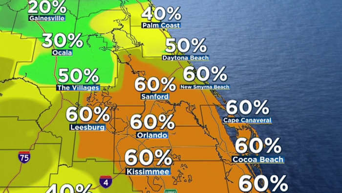
FRIDAY
Storm activity may begin as early as Friday morning, particularly along the I-4 corridor and northwest of Orlando. As the day progresses, anticipate more storms developing in the warm, unstable atmosphere, moving east-southeast at 15 to 25 mph. Despite their speed, these storms could be quite potent, delivering quick downpours with up to 2 inches of rain, frequent lightning, gusty winds between 40 to 50 mph, and even some small hail.
Though most storms will be typical for summer, there’s a slight risk that a few could escalate, producing wind gusts near 60 mph. Consequently, the Storm Prediction Center has placed the region under a Marginal Risk (level 1/5) for strong to severe storms.
And it’s not just the storms, heat is a big factor today, too. Highs will climb into the upper 80s to low 90s, and when you factor in the humidity, it’ll feel like 100 degrees.
WEEKEND
By early Saturday morning, another round of showers and storms is expected to move in from north to south as a late season cold front begins to slide through Central Florida.
Latest models are picking up on showers and storms sweeping across the region in the morning through lunchtime. The setup includes a small dose of instability which will increase a risk for a few stronger storms with winds, rain and lightning.
Most of the activity should move out by early afternoon as temperatures remain below average in the upper 80s with humidity levels dropping into the night.
By Saturday afternoon, those storms should push toward the Treasure Coast, with drier air gradually filtering into areas farther north.
Expect the most comfortable day in weeks to settle in by Sunday with low humidity and average temperatures in the upper 80s.
NEXT WEEK
Looking ahead to next week, the stormy pattern doesn’t completely disappear, but things should calm down somewhat. Rain chances will stay lower than recent weeks at 20-40% with highs in the low to mid 90s.
Copyright 2025 by WKMG ClickOrlando – All rights reserved.