
SAVANNAH, Ga. () — Fall begins Monday at 2:19 PM, but the true fall weather will hold off for a few days.
Sunday was another warm and muggy day, but a northeastern breeze helped to improve comfort levels. Rain largely held off for most regions, although spotty showers did emerge just before sunset as the sea breeze progressed inland.
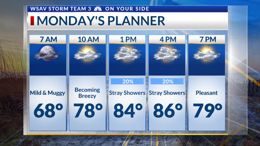
Northeastern winds are set to continue overnight Sunday and throughout much of Monday. A mild and somewhat muggy morning will transition into a warm and humid afternoon. It will feel a bit cooler due to stronger winds and increased cloud cover, with a 20% chance of rain.
Coastal areas may see stray showers, and there’s a possibility of spotty showers inland. Temperatures will reach the mid to upper 80s, making it the coolest day of the week.


The week will then see a hot and humid trend establish itself. Morning temperatures are expected to be in the 70s for some, with afternoons ranging from the upper 80s to low 90s. Humidity levels will rise, influenced by southerly winds.
A storm system accompanied by a cold front will enter the region by week’s end. This will bring increased rain chances from Thursday through the weekend, with the possibility of scattered thunderstorms from Friday into Saturday as the front passes.
Milder air will make its way into the Coastal Empire and Lowcountry by next weekend, with Fall air potentially settling in afterward.
The tropics have a few changes, with Gabrille intensifying into a hurricane and two other disturbances to watch.
Gabrielle has upgraded to a hurricane status as of the 5 PM advisory. The storm has about 48 hours to potentially intensify into a major hurricane before veering northeast into the North Atlantic.
Gabrielle will pass to the east of Bermuda and remain well off the east coast of the US. Our area may find higher swells for marine and beach interests, with rip currents being an issue this week.
A new area to watch, located 500 miles east of the Caribbean, has 20% odds of becoming a tropical depression or named storm over the next seven days. This was the first of the two disturbances to come off of Africa over the last week.
The trailing disturbance is showing improving organization, and the National Hurricane Center is giving it a 50% chance of developing into a tropical depression or named storm over the next seven days. Both of these features do not have any signals of becoming a strong system, and guidance turns them safely northward.
There continues to be no tropical threats for the Coastal Empire and Lowcountry.