
Share this @internewscast.com
We’re beginning the day with some areas of fog, which will clear up to a partly sunny sky, accompanied by temperatures that will reach the mid-80s, aligning with the seasonal norm. A stationary front off our coast remains, offering a chance for isolated showers and thunderstorms throughout today.
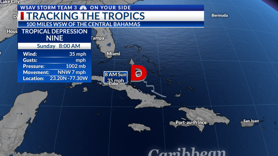
Looking ahead to tomorrow, our focus shifts to the tropics. In a positive update, Tropical Depression Nine is progressing significantly slower than initially expected. This delay increases the odds that major Hurricane Humberto will steer it away from us, which is excellent news! Nonetheless, there could still be local effects as it tracks northward past our coast over the coming days.
From the latest 8 a.m. advisory from the National Hurricane Center, Nine remains a Tropical Depression, with sustained winds at 35 mph and a minimum pressure of 1007 mb. It continues its slow NNW movement at 7 mph but is predicted to accelerate NNW later today into Monday. According to the forecast track, the system’s center is predicted to traverse the central and northwestern Bahamas today into tonight, approaching the southeast U.S. early in the week. Intensification is anticipated today, with the possibility of transforming into Tropical Storm Imelda, reaching category one hurricane strength by late Monday or early Tuesday. However, due to its sluggish pace, it is likely that Humberto, now a major category 4 hurricane, will redirect Nine out to sea. This crucial development lessens our potential impact though we could still experience some heavy rain bands, gusty winds, and coastal issues such as rip currents, high waves, and possibly minor storm surge.


Currently, a Tropical Storm Warning is in effect for the Central Bahamas, parts of northwestern Bahamas, and the east coast of Florida from the Palm Beach/Martin County Line to the Flagler/Volusia County Line. Meanwhile, a Tropical Storm Watch is active from Florida’s northern east coast up to the Glynn/McIntosh county line in Georgia, just below our viewing area. A Tropical Storm Warning indicates that tropical storm conditions are expected in the warned area within 36 hours, whereas a Tropical Storm Watch means such conditions are possible, usually within 48 hours. Additional warnings or watches may be issued later today as the situation develops.