
Share this @internewscast.com
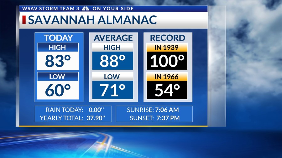
SAVANNAH, Ga. () — The streak of nice and comfortable weather continued for Wednesday. Afternoon highs reached the lower to middle 80s.


Despite a few clouds entering the region, the weather remains dry. We can expect the calm conditions to continue for several more days, with warmer afternoon temperatures and increased humidity.

A high-pressure system to our northwest is encouraging a northerly breeze that is bringing dry air into the southeast, also preventing the formation of showers or storms.

Warmer and more humid conditions will set up for the weekend and into next week as the wind becomes more onshore.
By the middle of next week, the likelihood of rain will rise as a new disturbance approaches the southeast. Until then, local conditions will stay calm.
TRACKING THE TROPICS
Sept. 10 is the statistical peak of hurricane season, and all is quiet with respect to tropical depressions or named storms in the Atlantic basin.

The National Hurricane Center is tracking a tropical wave set to move off the West coast of Africa. It has a low (20%) likelihood of developing into a tropical depression after moving into the eastern Atlantic’s open waters.
This system will encounter wind shear, dry air, and some Saharan dust that will hinder significant development in the near future.