Share this @internewscast.com
SAVANNAH, Ga. — The weather forecast is taking a turn, with rain expected to begin tonight, setting the stage for a cooler week ahead.
Sunday was marked by predominantly cloudy skies and intermittent breezes. As we move into the night, rain will make its presence known, brought on by an incoming storm system. Overnight temperatures will hover between the upper 50s and lower 60s, with northeast winds blowing at speeds of 5 to 15 mph.
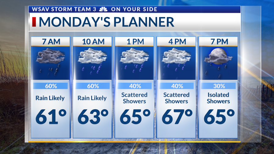
Come Monday, expect periods of showers accompanied by isolated storms, with rain becoming more frequent before dawn. The most intense weather activity will occur as a series of showers and embedded storms traverse the area. This will be driven by a developing low-pressure system, which will not only amplify the chances of rain but also increase the intensity of rainfall and maintain brisk winds.
Although heavy rain could lead to localized street flooding, the combination of dry soil and manageable rainfall rates should prevent any widespread flooding issues. While the likelihood of rain diminishes somewhat by the evening, scattered showers are expected to persist beyond sunset.
As the week progresses from Tuesday to Thursday, conditions will clear up and become cooler, with only a 20% chance of rain and daytime highs in the 60s. A robust cold front is set to sweep through the Southeast by Thursday, bringing clear skies and a noticeable drop in temperature to conclude the week. Halloween is shaping up to be quite chilly, with temperatures falling more than 10 degrees below the seasonal average!
Meanwhile, in the tropics, Hurricane Melissa remains a formidable force. As of 5 p.m., this system has intensified into a Category 4 hurricane with maximum sustained winds of 145 mph. Jamaica is bracing for a potentially catastrophic impact, with predictions of over 30 inches of rainfall, storm surges exceeding ten feet, and devastating winds from the storm’s core threatening to cause severe damage.
Melissa will track northeast away from Jamaica and impact eastern Cuba along with brushing Hispaniola. Southeastern portions of The Bahamas and the Turks and Caicos will also be impacted. The steering flow eventually takes the system out to sea, bringing potential impacts to Bermuda.
There are no tropical threats to the Coastal Empire and Lowcountry.