
Share this @internewscast.com
SAVANNAH, Ga. () — Thursday was hot and very humid around the Coastal Empire and Lowcountry.
Afternoon highs were in the lower 90s for most locations though heat index values were over 105°F at times.
A few lucky locations were cooled off briefly from a few showers and storms. More heat and humidity are in the forecast especially into the weekend.
The heat will be the main weather story Friday and into next week.
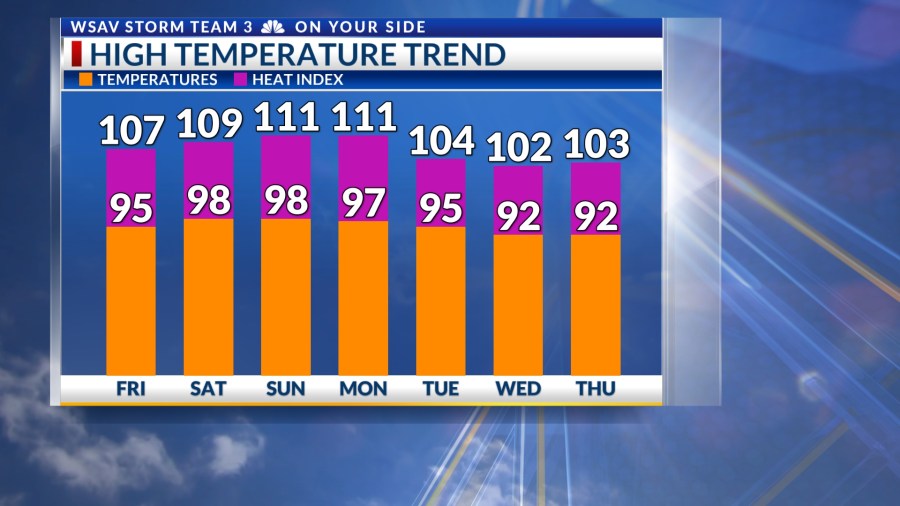
A LOOK AHEAD
Rain and storm likelihood will remain minimal in the coming days as high pressure establishes itself in the region. On Friday, afternoon temperatures are expected to reach the mid-90s, with heat index readings surpassing 105°F.
The upcoming weekend promises to be even hotter, with actual air temperatures climbing to the upper 90s, and some inland areas might reach 100°F. Heat index values could exceed 110°F at times from Saturday through Monday.

It’s important to note that the heat index reflects how the temperature feels on your body. As the index rises due to elevated humidity, it becomes increasingly difficult for your body to cool down.
Be sure to stay hydrated, take plenty of breaks, and try to spend as much time indoors or in the shade as possible.
It is a good idea over the next few days to limit strenuous outdoor activities to the cooler morning and to the evening hours.

Rain and storm chances will increase again by Tuesday of next week. More rain will lead to slightly cooler afternoon highs in the lower 90s, which is where we should be temperature wise this time of the year.
93°F is the average or normal afternoon high in Savannah for mid July. The all-time record high for Savannah is 105°F set back in July of 1879 and 1986.

TRACKING THE TROPICS
The system in the northern Gulf that had potential to become either a tropical depression or tropical storm now has very little chance of that occurring.
It has been riding the northern Gulf Coast which limited how organized it could become.
This disturbance is now located over eastern Louisiana and is nothing more than a heavy rain maker. Many areas in southern Louisiana have received over 8″ of rain over the past two to three days.
No other development is expected in the Atlantic basin over the next five to seven days.