
SAVANNAH, Ga. () — Tuesday afternoon brought hot and humid weather to the Coastal Empire and Lowcountry. Most areas reached highs in the low to mid 90s, with heat index values occasionally exceeding 105°F.
In Savannah, the temperature reached 95°F by 2:13 p.m., with a maximum heat index of 106°F. The remainder of the workweek is expected to bring more summer heat and storms.
A LOOK AHEAD
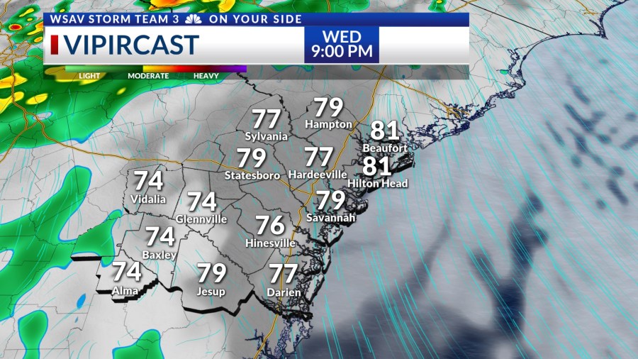
Wednesday morning will begin with partly to mostly cloudy skies and warm, humid conditions, with lows in the mid to upper 70s. Some showers and storms are anticipated to develop by mid-morning in our western areas, such as Montgomery, Jeff Davis, and Appling County.


Showers and storms will become more widespread by noon for areas generally west of I-95. Storms will continue to spread toward the coast as the afternoon goes on.
Showers and storms will likely continue into the early evening.
Afternoon highs will have no problem reaching the low to mid 90s, even with scattered storms in the area. The summer heat will add plenty of energy for storms to feed off of meaning that some storms may become strong to severe.

Damaging wind is the main concern with gusts over 60 mph. Hail is also possible with some of the stronger and taller thunderstorms. Wednesday’s overall severe risk is low.
However, you still should have a way to receive critical weather alerts and be ready to seek shelter if you will be outdoors.
The remainder of the work week for Thursday and Friday will continue to feature scattered rain and thunderstorms along with above normal afternoon high temperatures.
Rain and storm chances will start to back off over the weekend and into next week. This will allow afternoon highs to be even hotter in the mid to upper 90s.


TRACKING THE TROPICS
There are not currently any areas to watch for tropical development in the Atlantic basin over the next five to seven days. However, some long-range guidance indicates that there may be something to watch in the Gulf late next week.