
SAVANNAH, Ga. () — Wednesday afternoon and evening were certainly stormy across the Coastal Empire and Lowcountry.
Many locations inland had rain totals in excess of 2-3″, which led to some localized flooding concerns.
Savannah had several streets that were covered by several inches of water.
A LOOK AHEAD
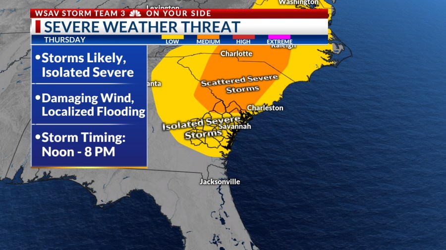
More storms are in the local forecast for Thursday, and some storms may become strong to severe.
The timing of Thursday’s storm activity is expected to be primarily after midday, stretching into the early evening hours. Our threat of severe weather will diminish as the sun sets and we lose the heat of the day.


Our main worry continues to be damaging wind gusts that could exceed 60 mph. There is also the potential for hail production from some of the stronger and more elevated thunderstorms.
Another concern is the heavy rainfall rates, which might cause localized flooding, especially in areas with inadequate drainage. Some storms could bring rainfall amounts exceeding 3 inches.


Another round of showers and storms is expected for Friday afternoon. A few storms may become strong to severe. However, the severe risk will be more limited than what we will have on Thursday.
Afternoon high temperatures on Thursday and Friday will be in low to mid 90s. This is even with the elevated storm chances. The extra heat is part of the reason why we will have at least a few isolated severe storms in our area.
Weekend rain chances will be lower than Thursday and Friday which will lead to hotter afternoon high temperatures. Saturday and Sunday will likely top out in the mid to upper 90s.
Many locations will have heat index values over 105°F at times.


Be sure to stay cool and hydrated and take plenty of breaks in the shade if you will be engaging in any outdoor activities. Keep an eye to the sky for a few isolated showers or storms. Also don’t forget, “when thunder roars, head indoors.”
TRACKING THE TROPICS
All is quiet as of Wednesday evening across the Atlantic basin. There are no areas to watch for potential development over the next five to seven days.
Some long-range global forecast models are hinting at the possibility of something organizing in the northern Gulf within the next 8 to 14 days.
Water temperatures are in the mid to upper 80s which is warm enough to support tropical development.
There is no threat to the U.S. at this time.