
Share this @internewscast.com
Tuesday afternoon was definitely a very hot and humid day.
Afternoon temperatures soared into the mid to upper 90s, with the heat index occasionally reaching up to 110°F. This trend of intense summer heat is expected to continue on Tuesday.
Along with the heat, some storms are also in the local forecast for Wednesday evening.
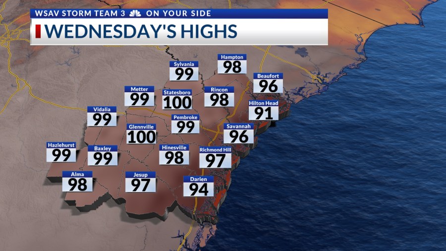
Wednesday is anticipated to bring periods of sunshine and clouds, with temperatures climbing into the upper 90s. At times, the heat index could exceed 105°. Consequently, heat advisories are expected to be issued once more across the Coastal Empire and Lowcountry.


This severe summer heat will contribute to the formation of a storm system in the evening. Starting around 6 p.m., storms are forecasted to approach from the northeast. By 9 p.m., these storms are likely to become more prevalent, particularly affecting our inland regions.

Storms will then be moving through and exiting our southwestern counties by midnight. Some severe storms are possible with damaging wind gusts as the primary concern. Heavy rain may lead to localized flooding issues in areas with poor drainage.


More storms are expected later in the week as an upper-level low that is located over the Bahamas moves toward to southeastern U.S. This low will help to draw in some deeper tropical moisture which will lead to higher rain and storm chances.
Rain chances over the weekend will be even higher as more moisture will be able to flow into the region.
Organized severe weather is not expected Thursday through the weekend, though the summer heat may lead to a couple of strong storms at times.
TRACKING THE TROPICS
The first named storm of the Atlantic hurricane season formed as of 11 a.m. EST. Tropical storm Andrea is a very small system located over the North Atlantic, several hundred miles west of the Azores.
Andrea poses no threat to any land at this time and is forecast to be a remand low as early as 2 a.m. Wednesday.
No other development is expected in the Atlantic basin at this time.