
Share this @internewscast.com
SAVANNAH, Ga. () — A warmer and more humid pattern is expected to stick around for this weekend into next week.
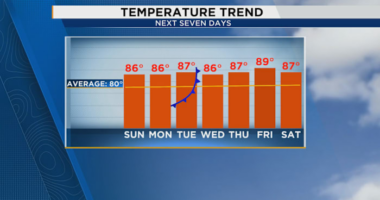
The heat and humidity persisted on Friday, with temperatures reaching 90° in several areas, while the humidity made it feel even hotter, with a heat index between 93° and 95°. Although a few showers and storms developed, they dissipated rather quickly.
Similar conditions are anticipated for the weekend, starting with mild and humid mornings that transition into hot and humid afternoons. The forecast includes partly cloudy skies with a 20% chance of rain each afternoon.
A high-pressure system will maintain warm and humid weather into the upcoming week. A disturbance in the mid and upper levels will bring additional atmospheric lift, leading to approximately a 30% chance of rain on Monday and Tuesday.


While fall officially begins at 2:19 PM on Monday, the advent of cooler temperatures will be attributed primarily to increased rain chances early in the week. The genuine feel of fall is likely to be delayed for several days. Predictions indicate a potent storm system will move through the Eastern US later in the week, but uncertainty remains about a cold front reaching our region.
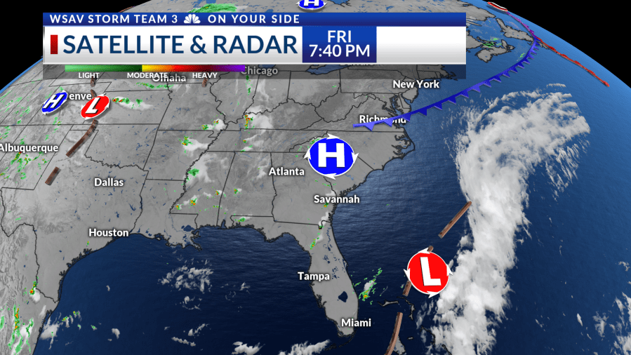
As of Friday night, there are no significant changes in the tropics. A tropical wave emerging from the African coast has a 20% chance of development over the next week. The Tropical Atlantic is still a challenging environment for development, but if the wave progresses westward, it will need to be monitored.
Tropical Storm Gabrielle, with maximum sustained winds of 50 mph, is moving northwest. The system is becoming better organized as thunderstorms develop around its center. Gabrielle is expected to slowly strengthen into a hurricane, tracking east of Bermuda before turning north.
There are no tropical threats for the Coastal Empire and Lowcountry at this time.