
Share this @internewscast.com

Hi, hi – StormTeam 3 Meteorologist Alysa Carslye here – let’s have a fabulous Friday and first day of August!
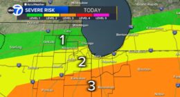
It’s another scorching day with temperatures reaching the mid to upper 90s and a heat index climbing up to 112°. A heat advisory is in place from 11 am to 8 pm this evening for the entire region. The promising news is that the cold front we’ve anticipated all week will arrive Friday night. Before its arrival, expect late-day showers and thunderstorms. Some of these storms could become strong and severe, potentially causing damaging winds. Overnight, waves of heavy rain will persist.
This weekend, both Saturday and Sunday will experience a brief break from rain and storms in the morning, but showers will redevelop in the afternoon. The front will position itself to our south and become stationary. Due to the stagnant nature of the front, storms will move slowly, leading to heavy rain and potential street flooding in localized areas. Rainfall totals from the weekend through Monday evening are expected to range from 3 to 5 inches. This rainfall will be much-needed as we’re currently about 3 inches below the average rainfall for this time of year.
Regarding temperatures, relief from the heat is on the way! Expect highs in the upper 80s to low 90s on Saturday and then cooling to the mid-80s on Sunday. By Monday morning, temperatures in some inland areas might even start in the 60s.
As a reminder, the following counties go back to school on Monday, August 4th: Appling, Bacon, Chatham, Jasper, Long, & Screven.