
Share this @internewscast.com
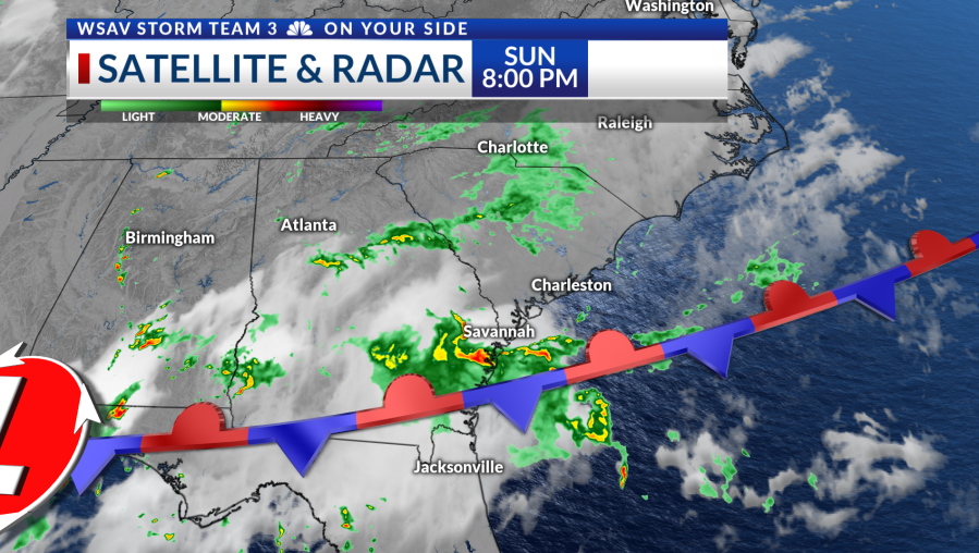
In Savannah, Georgia, northeast winds caused the afternoon temperatures to drop about 10° below the typical range. After early morning storms over the Lowcountry subsided, Sunday remained cloudy and mild from morning into the early afternoon.
Although storms were slow to develop, they eventually moved north of the Altamaha River in the late afternoon. Some areas experienced minor flooding due to saturated ground, but most storm activity weakened as it moved north.
This evening in the Coastal Empire, showers and a few storms, particularly along I-95, are anticipated. These showers and storms will taper off overnight, except for another round that may occur along the immediate coast around sunrise.

Monday
Monday’s forecast mirrors Sunday’s, with the stationary front lingering over the area. A round of showers and storms is possible in the morning, followed by additional storms in the afternoon.
Afternoon temperatures are predicted to stay below average, reaching only the mid-80s. As the week progresses, the weather is expected to gradually shift back to typical summer conditions with heat, humidity, and storms.
The stalled front will continue to contribute to storm development, and scattered storms are expected from Tuesday through Thursday due to daytime heating.

Tropics
The tropics are waking up as typical for August. The National Hurricane Center has 3 areas to watch with Invest 95-L off the North Carolina Coast, a tropical wave moving off of Africa, and another area to watch later this week to the east of our area.
Invest 95-L has a 80% chance of developing into a depression or named storm over the next day or two. The system will harmlessly move offshore.
A tropical wave moving off of Africa has a near-zero chance of developing over the next two days. There is a 40% chance of development over the next 7 days.
It is important to know that there is a lot of time to track this feature and no details will be clear until a center is clearly defined. The Atlantic Basin is still fairly inhospitable for tropical systems due to dry air and dust.
Another area to watch is off of the Southeast Coast. An area of low pressure may form east of our area and drift towards the coast. There is a 20% chance of a tropical depression or named storm over the next week but details are not clear at this time.
There are no tropical threats for the Coastal Empire & Lowcountry.