
Share this @internewscast.com
TAMPA, Fla. (WFLA)— Tropical Storm Erin is expected to strengthen and become a hurricane today, the National Hurricane Center said.
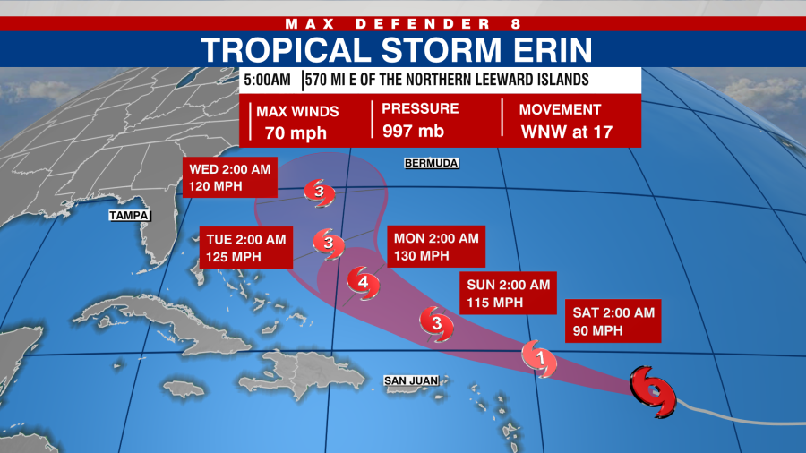
Located approximately 570 miles east of the northern Leeward Islands, Erin is moving toward the west-northwest at a speed of about 17 mph.

This movement is expected to continue into the weekend as Erin is likely to move near or north of the northern Leeward Islands over the weekend.
Maximum sustained winds are near 70 mph.
The National Hurricane Center (NHC) predicts that Erin will strengthen over the next few days, likely reaching hurricane status later today and potentially becoming a major hurricane by the weekend.
Tropical Storm Erin is forecast to become a Category 4 hurricane.
A tropical storm watch is in effect for:
- Anguilla and Barbuda
- St. Martin and St. Barthelemy
- Saba and St. Eustatius
- Sint Maarten
Southeastern Gulf
A weather disturbance situated over the western Gulf might briefly develop into a tropical depression before making landfall in northeastern Mexico or southern Texas later today or tonight, according to the NHC.
Regardless of development, heavy rainfall is possible along parts of northeastern Mexico and southern Texas over the next couple of days.
According to the NHC, an Air Force Reserve Hurricane Hunter aircraft is scheduled to investigate the system this morning.
The chance of formation in the next 48 hours and 7 days is 50 percent.
Watch Tracking the Tropics on Tuesdays at 12:30 p.m. ET/11:30 a.m. CT
Tune in on Spotify or Apple Podcasts. Stay prepared with the 2025 Hurricane Guide and keep informed about tropical developments with the Tracking the Tropics newsletter.