
Share this @internewscast.com
ORLANDO, Fla. – As sea breezes develop, a few isolated showers might pop up on Saturday, though most regions will remain dry under partly cloudy skies, accompanied by breezy winds. Overnight, temperatures are expected to dip into the 60s, with the possibility of patchy dense fog forming late at night, which should dissipate roughly an hour after sunrise.
Speaking of sunrise, don’t forget that Daylight Saving Time kicks in on Sunday. Remember to set your clocks forward by one hour. While Saturday’s sunrise was at 6:43 a.m., Sunday will see it at 7:42 a.m. As we edge closer to the Spring equinox on March 20, we’re gaining additional daylight.
Expect Sunday to bring a warm atmosphere, with temperatures soaring into the mid to upper 80s and a 30% likelihood of experiencing scattered showers and thunderstorms.
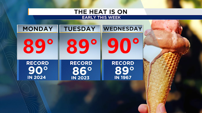
As we move into the early part of the week, temperatures are expected to hover near record highs. However, a cold front arriving on Thursday will elevate rain chances to about 50%.
Following the passage of the front, cooler temperatures will prevail, with Friday’s highs dropping back to the seasonal norm in the upper 70s.
Copyright 2026 by WKMG ClickOrlando – All rights reserved.