
Share this @internewscast.com
Jeff Berardelli serves as the Chief Meteorologist and Climate Specialist at WFLA. Stay updated on Tampa Bay’s weather and climate by following him on X and Bluesky.
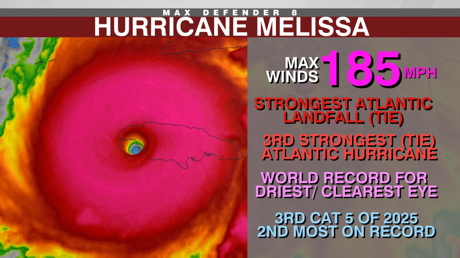
TAMPA, Fla. (WFLA) — Hurricane Melissa has matched the 1935 Florida Keys Labor Day hurricane as the most powerful storm to make landfall in the Atlantic, setting a new record.
Both of these formidable hurricanes struck with winds reaching 185 mph and a barometric pressure of 892 mb.
However, these aren’t the only records being highlighted in today’s Berardelli Bonus.
One significant factor behind Melissa’s intensity was its position over the Atlantic Basin’s warmest waters. This wasn’t merely about warm surface temperatures; the deep waters were also unusually hot, providing an almost unlimited energy source in the Caribbean. This region is well-known for producing potent storms in October.
- Strongest Atlantic landfall (Tie)
- Third strongest Atlantic hurricane (Tie)
- World record driest/clearest eye
- Third 2025 cat 5 (Second most)
- Fourth extreme rapid intensification episode of 2025 (Tied for first place)

The reason Melissa was able to get so strong is it was positioned over the hottest water in the Atlantic Basin. Not just hot surface water, but deep-hot water, providing an endless supply of energy in the Caribbean. That’s an area notorious for strong October storms.
That water was 2-3 degrees Fahrenheit above recent normals and a few degrees above what would have been normal just four decades ago. This warmer water is mainly due to manmade climate change, which has warmed the oceans significantly — especially over the past 50 years.
Two rapid analyses on the impact of climate change on Melissa found that the winds and rain were made stronger by warmer waters. The image below shows an analysis by Climate Central. The intensity of hot water under Melissa was made 800 times more likely by climate change.

That warmer water likely enabled Melissa to get about 10-15% more intense than it otherwise would have been in the 20th Century.