Share this @internewscast.com
SAVANNAH, Ga. () — The next few morning and midday high tides will continue to bring coastal flood concerns while we track a developing coastal low.
Thursday brought a gloomy, cool day to the region. Coastal temperatures struggled to reach 70, while inland areas achieved mid and upper 70s. Light rain occurred occasionally, particularly along the immediate coast.
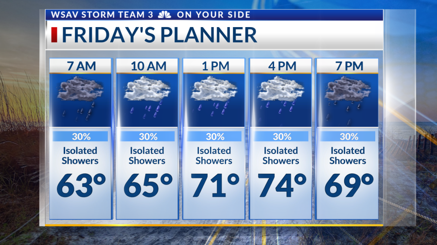
Friday will start mildly in the 60s, leading to a breezy and comfortable day with highs in the 70s. Winds will range from 10-15 mph, with gusts of 25 mph or higher, especially east of I-95. A 30% chance of passing showers exists, but substantial rainfall isn’t expected. Rain chances decrease by Saturday, with only coastal showers early in the weekend.


The developing low-pressure area will keep winds elevated over the next few days. On the beach and at sea, several alerts are active, including a High Surf Advisory until Sunday morning and a Gale Warning through at least Saturday night.
Coastal flooding remains a concern due to king tides and onshore flow. Midday high tides on Friday and Saturday will exceed 10 feet at Fort Pulaski, with Friday’s high tide predicted at 10.4 feet. Highway 80 between the Bull River Bridge and Tybee Island might require closure with the 11 a.m. high tide.
Rain chances diminish and winds decrease through the weekend, leaving pleasant fall air for early next week, with morning temperatures in the 50s for much of the area!


Tracking the Tropics
No significant changes in the tropics as Tropical Storm Jerry approaches the Northern Leeward Islands, and a disturbance in the North Atlantic attempts to develop.
Jerry remains poorly organized with 65 mph maximum sustained winds. Wind shear has taken a toll on the system as most convection remains east of the center. Jerry will brush the Northeast Caribbean, then track northward into the Central Atlantic, potentially strengthening into a hurricane.
An area of low pressure tagged as Invest 96-L over the North Atlantic may briefly develop into a tropical system tonight into tomorrow, with the National Hurricane Center giving it a 40% chance of doing so.
There continues to be no tropical threats for the Coastal Empire and Lowcountry.