
Share this @internewscast.com
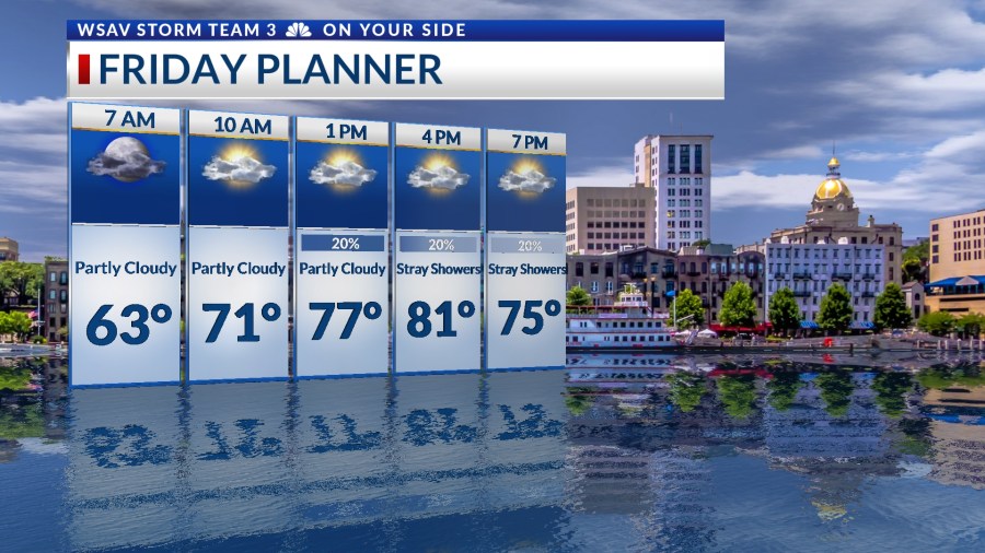
In Savannah, Georgia, Thursday afternoon brought mild and breezy conditions, which are expected to continue into Friday, accompanied by a few occasional showers.

A low-pressure trough is forming off the coast, increasing cloud cover and the likelihood of some showers on Friday and Saturday. Temperatures during the afternoons are anticipated to reach the upper 70s to lower 80s.
Heavy, widespread rainfall is predicted from Sunday into Monday as the low-pressure trough moves west across Florida and into the northern Gulf. Rainfall amounts are expected to surpass 3 inches, with the heaviest rain near the shore.


Expect breezy and gusty conditions from Friday through the weekend, particularly along the coastal areas. There is also concern for rough seas and rip currents. A persistent northeast wind will cause tides to be higher than usual over the weekend.
Minor coastal flooding is possible on Saturday and Sunday.

Rainfall chances begin to diminish on Tuesday, continuing into the middle of the next week. Temperatures are likely to rise back to the mid 80s as conditions become slightly sunnier and drier.
TRACKING THE TROPICS
Hurricane Imelda has transitioned into a post-tropical low in the North Atlantic. The National Hurricane Center issued its final advisory at 11 a.m. EDT on Thursday, as Imelda merged into the same cold front that encompassed Humberto earlier this week.

Elsewhere in the Atlantic basin, the National Hurricane Center is monitoring two tropical waves for further development.
The first tropical wave is located just off of the east coast of Florida. This is the same system that will help to enhance our local rain chances this weekend.
It currently has a low (10%) chance of developing into a tropical depression or tropical storm over the next 5-7 days. The main concern from this system will be heavy rain for the southeastern U.S.

A second tropical wave is currently located over western Africa. It is forecast to move off of the coast over the next couple of days. This system has a low (30%) chance of developing into a tropical depression or tropical storm over the next 5-7 days.
The environment will support slow organization and development as the system moves westward toward the Caribbean Sea. This system poses no threat to the U.S. at this time.