
Share this @internewscast.com
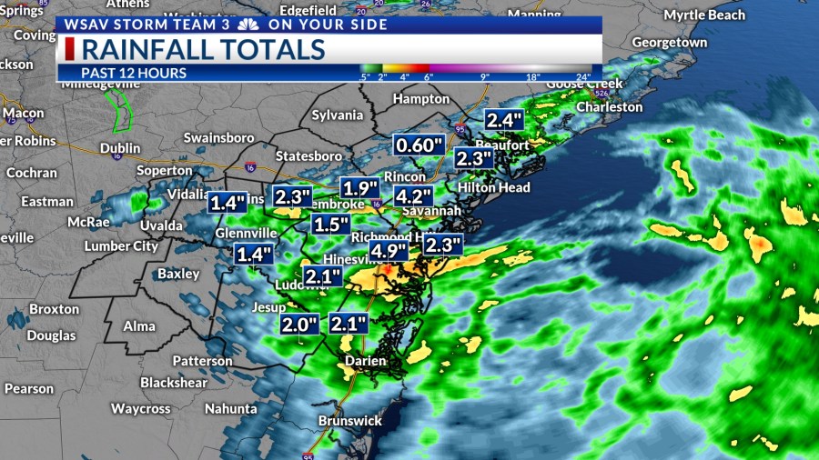
Friday turned out to be a very wet day across the Coastal Empire and Lowcountry, with Savannah experiencing significant street flooding due to heavy rainfall.

VIPIR Radar measured rainfall exceeding 3 inches in certain areas of Chatham County, while Bryan and Liberty Counties along Interstate-95 also dealt with substantial rain. However, by Friday evening, most of the floodwaters had drained from the roads.
However, more heavy rain is on the way for the weekend.


A LOOK AHEAD
A persistent trough of low pressure, which has been increasing our rain chances throughout the week, will remain through the weekend. Expect periods of heavy rain on Saturday, Sunday, and continuing into Monday.
This mid-level trough is advancing westward towards Florida, channeling more tropical moisture into our region. Rainfall could reach rates of over 1 to 2 inches per hour at times, potentially causing localized flooding.
Rainfall totals will be in excess of 3″ for some locations through Monday.


The cloudy and wet pattern will help to keep conditions mild in the upper 70s to lower 80s for high temperatures Saturday through Monday.
Rain showers and thunderstorms will begin Saturday morning, persisting through the afternoon and early evening. Sunday’s storms are expected to follow a similar pattern, starting mid-morning and lasting into the afternoon.
Rain on Monday will be concentrated in the afternoon and early evening.

By Tuesday, rain and storm chances will decrease, leading to a drier pattern for the upcoming workweek, with much higher afternoon temperatures expected.
High temperatures will be back into the lower to middle 90s by Thursday and Friday. The humidity will lead to heat index values in the upper 90s to 100°F.
TRACKING THE TROPICS
The National Hurricane Center (NHC) is monitoring two tropical waves in the Atlantic basin for further development.
A well-defined tropical wave has been moving through the central Atlantic over the past few days. It was looking to become more organized this weekend, though it is now moving into an environment that is not a conducive for tropical development.
The NHC gives it a medium chance (now 40%) for development into a tropical depression or tropical storm over the next 5-7 days. There is no threat to land from this system regardless of development or not.

A second tropical wave is in the process of moving off of the west African coast as of Friday evening. This tropical wave is weak and not very organized at this time. The environment will support some slow organization and strengthening as this system moves westward.
The NHC gives this a low (20%) chance of developing over the next 5-7 days into either a tropical depression or tropical storm. The Caribbean Islands will need to keep an eye on this system.
A weaker tropical system is more likely to continue a westward path rather than turning northward like the first tropical wave we are tracking. There is no threat to the U.S. at this time.