
Share this @internewscast.com

The remainder of your Saturday promises to be pleasant, with mostly clear skies and temperatures gradually cooling down to the 70s after sunset.
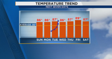
As Sunday dawns, expect a bright start with mostly sunny conditions, and temperatures hovering in the upper 60s to near 70 degrees. However, as a weather front moves in by the afternoon, a few late-day showers or a thunderstorm might develop. The day will feel a bit more humid, with a southern breeze pushing temperatures into the upper 80s.
Come Monday and Tuesday, the front will linger, bringing a slight possibility of some residual showers. Morning temperatures will sit in the upper 60s to lower 70s, while daytime highs will reach the upper 80s.
By Wednesday, a second front will clear the skies and reduce humidity levels. Expect morning lows around 70 degrees, with daytime highs remaining in the upper 80s.
Thursday and Friday promise cooler starts, with morning temperatures in the mid to upper 60s. The afternoons will be sunny and less humid, with highs ranging from the mid to upper 80s.
Looking ahead to next weekend, there’s a minor chance of showers as tropical moisture pushes in from the south. Despite this, temperatures should continue to peak in the upper 80s.
There is a tropical wave in the south Atlantic that will move westward into the Caribbean over the next several days. Slow development is expected as it moves toward Central America, but is not forecast to impact the United States. This wave has a 30% chance of development over the next seven days.
There is one other area of low pressure in the northern Atlantic that has a 10% chance of development as it moves away from the United States.