
Share this @internewscast.com
SAVANNAH, Ga. () — Get ready for a brisk weekend in Savannah, with Sunday bringing a fresh chance for some rain.
This year’s Halloween marked the coolest since 2012, as morning temperatures hovered in the 40s, climbing to highs around the mid-60s. Expect a chilly night with light winds and clear skies, leading to rapid cooling after sunset.
Overnight temperatures are set to fall into the upper 30s to lower 40s, except along the immediate coastline, which will stay around 45°. Some inland areas might experience a light frost on Saturday morning, but significant impacts are unlikely.
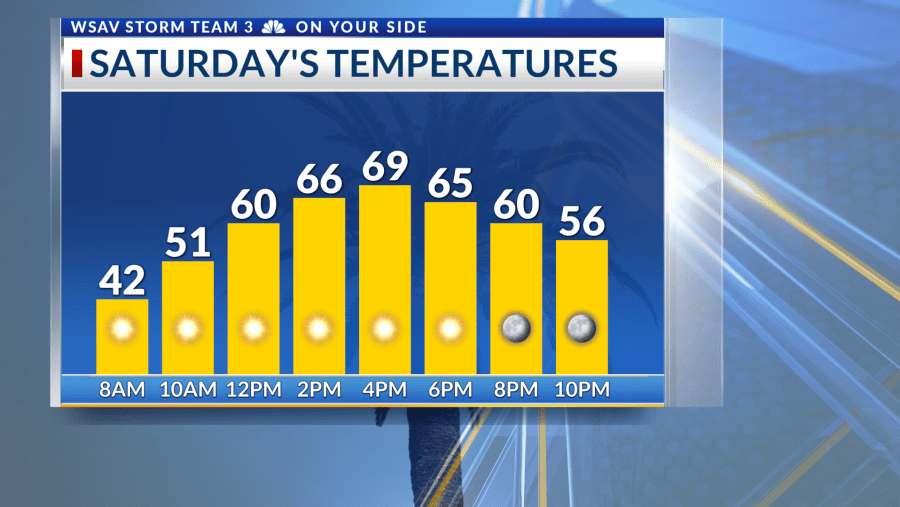
Saturday promises plenty of sunshine and mild weather, with temperatures reaching the mid to upper 60s for many. A swift-moving storm system is expected to roll in, bringing cloud cover and rain chances by Sunday.


This system is relatively weak, with its fronts losing momentum as they approach. Anticipate about a 20% chance of brief showers from midday Sunday through Monday morning. Neither day will be a complete washout, and conditions should dry out by Monday afternoon.
Looking ahead to next week, expect calm weather as high pressure settles over the area. Rain chances will be minimal throughout the week. Mornings will start cool in the 40s and 50s, while afternoons will be mostly sunny, with temperatures climbing into the 70s by midweek.
Tracking the Tropics
Melissa has officially transitioned into a post-tropical system as of the 11 a.m. advisory from the National Hurricane Center. It will affect Newfoundland tonight as a powerful hurricane-force system before moving across the North Atlantic this weekend.
The system left behind a devastating and deadly path in the Caribbean, with Jamaica bearing the brunt of the impact. It was the third Category 5 hurricane of the season and the most impactful storm of the year.
There are currently no additional areas being monitored by the National Hurricane Center, and no tropical threats to the Coastal Empire and Lowcountry.