
Share this @internewscast.com
Residents in southern and eastern Australia are in for a weather rollercoaster today, with forecasts predicting winds reaching 100 km/h and temperatures climbing close to 40 degrees Celsius.
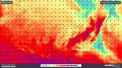
According to Weatherzone, a powerful low-pressure system swirling in the Southern Ocean is behind this unusual mix of weather conditions.
“As cold polar air pushes northward, it pulls warm air from the continent’s interior southward, driven by strong north-westerly winds, as air naturally moves from high-pressure to low-pressure areas,” the agency explains.

Feeling like winter in three states
The Bureau of Meteorology noted that this wintry shift first hit Tasmania overnight, catching residents by surprise.
In Tasmania, high temperatures are expected to hover around 17 degrees Celsius. However, with the wind chill factor, it will feel significantly colder, likely dropping to around 10 degrees throughout the day.
Showers are anticipated across the entire state, and there is a possibility of hail and snow in the western regions.
When the polar air moves across the Tasman Sea in coming hours, Victoria and southern NSW can expect much of the same conditions.
A damaging wind warning has been issued for the state’s eastern ranges, with gusts of 110km/h forecast for Alpine regions.
Heat is on in the east
Meanwhile, mid-autumn will feel like high summer for parts of eastern NSW and South-East Queensland.
Brisbane is set for a sunny day with temperatures in the centre of the city reaching a top temperature of 30 degrees, while in the western suburbs the mercury will soar to 37 degrees.
NSW residents should expect similar temperatures, with some parts pushing for record temperatures.
Central Sydney is forecast for a top of 33 degrees, with the city’s west will be two degrees warmer.
Similar maximum temperatures are also set for the regional cities of Wollongong, Newcastle and Maitland. It will be even hotter through the north-west, with Bourke up to 39 degrees.
Forecasters say the hot conditions in NSW will be over by tomorrow as the cooler air moves north later today.
With the polar conditions tightening their grip, there’ll be snowfalls in the Victorian high country, the Snowy Mountains of NSW, and higher parts of Tasmania.
NEVER MISS A STORY: Get your breaking news and exclusive stories first by following us across all platforms.