
Share this @internewscast.com
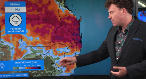
“It’s possible that one or two areas could receive up to 300mm of rain over the coming days if they experience multiple waves of those intense storms on Friday and through the weekend,” meteorologist Angus Hines stated on Thursday.

Although the most severe rainfall was circumvented, some sections of the southeast experienced significant precipitation.
The coastal trough shifted from the Gold Coast on Thursday into Friday, then progressed northward, settling around the Wide Bay Burnett area by Friday afternoon.
In the Gold Coast vicinity, rainfall reached 125mm in the 24 hours leading up to 9am on Friday, with Burleigh Waters Alert documenting one of the highest daily totals at 126mm.
STAY INFORMED: Ensure you’re the first to know about breaking news and exclusive stories by following us on all social media platforms.