
Share this @internewscast.com
Initially, predictions suggested the storm would make landfall as a category 3 hurricane.

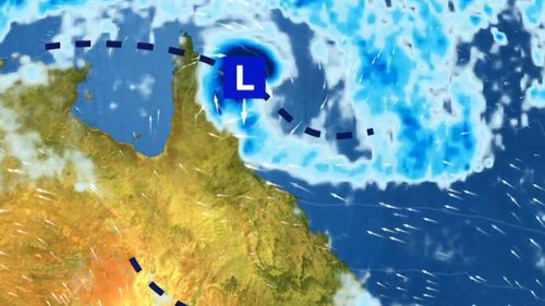
By 4 pm (AEST), Cyclone Narelle had downgraded to a category 1 storm, with its center experiencing wind speeds of 85 km/h and gusts reaching up to 120 km/h.
According to the bureau, “Narelle is anticipated to steadily progress westward, nearing the far northeastern coast of Queensland between Lockhart River and Port Douglas. A significant impact is expected towards the end of the week.”
Communities in the area are bracing for potential heavy rainfall, flash flooding, and elevated tides.
Meteorologist Dean Narramore noted that the adverse weather conditions are likely to remain offshore until at least Thursday.
“As the tropical low pressure system and forming cyclone near far northern Queensland on Thursday and Friday, the winds are expected to shift more to the east-southeast,” he explained.
“That will allow rainfall and winds to increase, particularly north of around Townsville and especially along parts of the north tropical coast from Thursday night into Friday.
“In terms of rainfall, many coastal areas are unlikely to see much over the next couple of days while the system remains further away.
“But as it approaches the coast on Thursday and Friday, heavy rainfall will begin to develop across parts of the north tropical coast.”
Once the system crosses the Queensland coast, it is expected to move out into the Gulf of Carpentaria over the weekend and possibly over towards the Top End.
People in the region are advised to stay up to date as the intensity and forecast track map of the system is still unclear.
Flood watches are in place for many areas of far northern Queensland and more widespread heavy rainfall is expected.
NEVER MISS A STORY: Get your breaking news and exclusive stories first by following us across all platforms.