Share this @internewscast.com
In brief
- Cyclone watch cancelled for Far North Queensland but wild weather is still expected.
- Residents asked to watch for alerts and observe flood emergency warnings.
- Up to 240ml of rain expected to fall in a six-hour period on Friday.
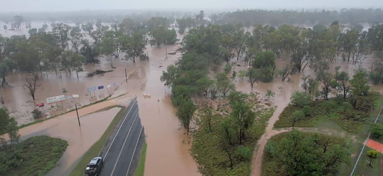
Flash floods have struck Far North Queensland overnight, and more rain is in the forecast, prompting residents to seek refuge on higher ground.
As Far North Queensland anticipates the arrival of a tropical low, authorities have advised many locals to evacuate due to the flooding situation.
At 9:30 p.m. on Thursday, police issued an urgent flood warning for the Daintree River, indicating that flash floods were already underway and urging residents to move to safer, elevated areas.
In anticipation of the storm’s impact, sandbag stations have been set up. Heavy rainfall, potential flooding, and damaging winds are predicted for Friday as the tropical low approaches the northeast of Cairns.
The Bureau of Meteorology (BoM) has projected that up to 240 millimeters of rain could fall within a six-hour window on Friday, posing a threat of severe and potentially life-threatening flash floods.
The adverse weather conditions have already taken a toll on local infrastructure, with the Daintree Ferry being dislodged from its moorings due to the extreme conditions.
Council and emergency crews will attempt to retrieve the vessel once conditions allow, Douglas Shire mayor Lisa Scomazzon said.
“We ask for everyone’s patience and understanding as we continue to deal with a major flooding event that is affecting the entire region,” she said.
A cyclone watch for the region was cancelled on Thursday after the system was considered a very low chance of intensifying before hitting the coast.
The “disconnected” tropical low was likely to reach the coast by Friday afternoon between Cairns and Townsville before moving southwest into central Queensland on the weekend, the BOM’s Angus Hines said.
Cassowary Coast mayor Teresa Millwood said emergency services were ready to deploy in Innisfail and Cardwell and sandbag stations were ready if people needed them.
Residents had been advised to have their emergency plans in place, stock up on supplies and be ready to leave before their homes flooded, she said.
“You never know until it actually happens, but we’re prepared,” she said.
“Basically, we just sit back and wait now.”
Hinchinbrook Shire mayor Ramon Jayo said his community had been warned to expect heavy rain and high winds.
“We’ve got a load coming at us … but we’re ready,” he said.
“We just got rid of a major flood last Monday and we’re lining up again for some more flooding.”
The usual warnings about floodwaters had gone out to residents who knew the drill, he said.
“They’re restocking their pantries in case they are stranded for a period of time due to floodwater.”
Other parts of the state would also cop severe weather as the system crossed the coast on Friday, Hines said.
The coast from Townsville down to Mackay will also be an area to watch.
Heavy falls could continue over north Queensland but might also stretch down through the Central Coast, Capricornia and into the Wide Bay region, around Bundaberg and Hervey Bay.
The impacts could also be felt in southeast Queensland at the weekend, Hines said.
Southeast Queensland residents have been asked to keep track of forecasts, especially for rain on Sunday.
For the latest from SBS News, download our app and subscribe to our newsletter.