Bureau of Meteorology’s senior meteorologist, Miriam Bradbury, has reported ongoing showers and storms sweeping through the far southwestern regions of the state due to an advancing low-pressure trough.

She cautioned that these weather disturbances might lead to significant rainfall, which could cause flash flooding. Additionally, widespread riverine flooding remains a concern across large parts of the state.
Currently, a low-pressure system known as 29U is positioned over the Coral Sea. The bureau estimates a 25% probability of this system evolving into a tropical cyclone by Thursday or Friday, with a potential trajectory leading it to make landfall between Cairns and Mackay.
In the north of Western Australia, two more tropical lows, identified as 28U near Christmas Island and 30U off the Kimberley coast, each have a 25% chance of developing into tropical cyclones on Thursday, according to forecasts.
Additionally, a fourth system, 31U, has emerged in the Gulf of Carpentaria and is anticipated to drift westward over the Northern Territory. However, it has a minimal likelihood of transforming into a tropical cyclone.
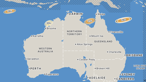
Regardless of their development into cyclones, the presence of several low-pressure systems alongside a monsoon trough is expected to bring extensive cloud cover, rain, and thunderstorms to northern Australia throughout the week, as reported by Weatherzone.
“Some computer models also suggest that at least one of this week’s eastern low pressure systems will drag heavy rain over central and southeast Queensland towards the end of the week,” Ben Domensino from Weatherzone said.
“If tropical cyclones do develop this week, parts of northern and eastern Australia could experience intense rain, flash flooding, damaging to destructive winds, large waves and coastal inundation.”
Australia has already had nine tropical cyclones form this season, which extends from November to April.
The next four tropical cyclones will be named Narelle, Oran, Peta and Riordan.
NEVER MISS A STORY: Get your breaking news and exclusive stories first by following us across all platforms.