Share this @internewscast.com
Rare footage from inside the eye of a hurricaine has been captured.
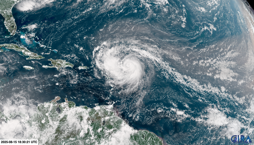
Erin has developed into rare Category 5 and it is now churning through the Atlantic Ocean north of the Caribbean.
The 53rd Weather Reconnaissance Squadron, popularly known as the Hurricane Hunters, conducted flights into Hurricane Erin’s eye on both Thursday and Friday to collect crucial weather data on the impending storm.

“Yesterday evening, the Squadron flew into Hurricane Erin’s eye and captured the stunning stadium effect,” announced the AF Reserve Hurricane Hunters on Instagram.
“These missions are essential for supplying the National Hurricane Center with vital data that enhance forecast accuracy, ultimately aiding in the protection of communities prior to landfall.”
The NOAA Aircraft Ops Centre also flew through Hurriance Erin as it became a category 5 storm Saturday.
The hurricane is now one of the fastest rapidly intensifying storms in the Atlantic Ocean’s history.

Erin went from a Category 1 hurricane with 120km/h winds at 11am local time Friday to a Category 5 with near 257km/h winds just over 24 hours later.
This marks Erin as a historical Atlantic hurricane due to its rapid intensification, possibly achieving the fastest strengthening before September 1 in recorded history.
Rapid intensification is when a hurricane gains at least 56km/h of wind speed in at least 24 hours.
However, it is not expected to hit land.


