
Share this @internewscast.com
The long weekend cold snap across Australia’s south-east will continue through this week, with the blast of frigid weather tracking north.
Victoria, New South Wales, Tasmania, and South Australia experienced a chilly King’s Birthday public holiday, but starting tomorrow, Queenslanders will need to reach for their winter coats and turn up the heat.
According to the Bureau of Meteorology, a low-pressure system in the Tasman Sea, combined with a high-pressure system over the Great Australian Bight, is pushing cold, south-westerly winds into Queensland.

Senior meteorologist Dean Narramore explained, “The cold weather that affected south-eastern Australia over the weekend is now moving further north and east.”
The weather system will continue tracking across into Queensland over coming hours and linger for much of this week.
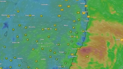
Residents should expect minimum temperatures to drop five to 10 degrees below the seasonal average over coming days.
Brisbane is heading for a minimum temperatures of 9 degrees and maximums of 19 degrees for the remainder of this week before the mercury rises on Saturday.
But further west, in the city of Ipswich, minimum temperatures are forecast to plunge to just 4 degrees.
Morning frost is likely to develop across Inland areas of Queensland and northern NSW.
“There will be a big burst of winter across eastern and south-eastern Australia,” said Narramore.
A large chunk of windswept NSW can also expect gusts dragging the ‘feel like’ temperature down to continue tomorrow.
Sydney is heading for a maximum temperature of 18 degrees tomorrow, while minimum temperature will struggle to reach double figures for the rest of this week.
But communities in the west of NSW will really feel the brunt of the cold snap.
The regional city of Wagga Wagga will see the mercury plunge to a minimum temperature of just 2 degrees by Thursday, while it will sink to -6 degrees in Thredbo.
The bureau has issued a gale warning for areas from the Macquarie Coast to the Eden Coast.
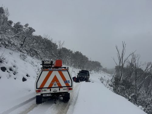
Snow falls of 40cms to 60cms were recorded across Alpine regions on the weekend, and early today there were more falls on the Northern Tablelands in NSW.