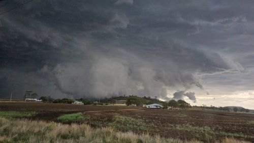

Residents in northern New South Wales, the Gold Coast, Brisbane, and the Sunshine Coast are being urged to remain indoors tonight as powerful ‘super cell’ thunderstorms sweep through the region. As of 10 p.m., severe storm warnings are still active.
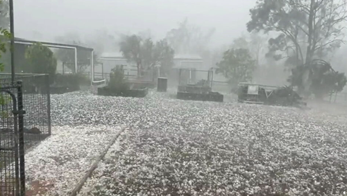
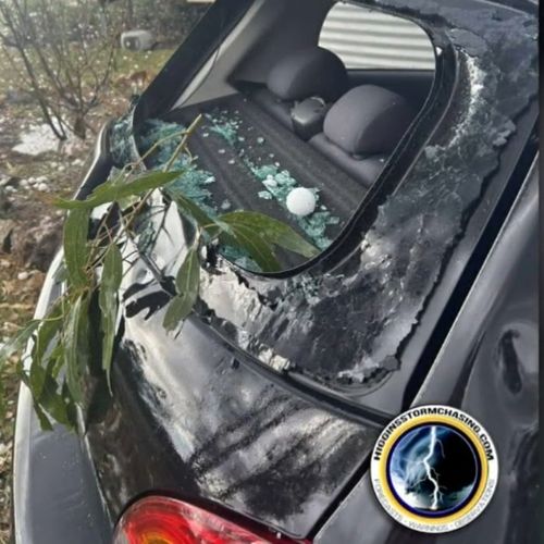
This afternoon, the storm hit Queensland’s Southern and Darling Downs areas, unleashing hailstones up to nine centimeters in diameter.

Hailstones measuring between 5 to 8 centimeters bombarded Toowoomba, Gatton, the Sunshine Coast, the Lockyer Valley, and Brisbane, accompanied by heavy rainfall that continues to soak the area.
By 3 p.m., Brisbane was engulfed by a dramatic display of lightning and dark clouds, which led to power outages affecting nearly 700 residents in Bowen Hills.
The Bureau of Meteorology (BoM) has issued warnings for damaging winds, large hail, and intense rainfall, which could lead to flash flooding throughout northern New South Wales and much of Queensland.
“Regarding the wind, there’s even a slight possibility that we could witness a tornado or two with the most intense and severe storm cells later today,” stated BoM meteorologist Angus Hines.
The worst of the storm is expected to hit Surfers Paradise, Gold Coast, the Brisbane metro area, the Sunshine Coast, Maleny and Noosa Heads.
The Burnett region, Kingaroy and Gympie, as well as Biloela and Toowoomba are also in the firing line, Bureau of Meteorology meteorologist Angus Hines said.
Residents in the NSW Northern Tablelands and across the North West Slopes and Plains, including Tamworth and Moree are also expected to be hit by the storms.
Coastal areas such as Port Macquarie, Coffs Harbour, Grafton, Ballina, Lismore and Byron Bay are also in the firing line.
Residents have been advised to pack away or secure outdoor furniture, toys and trampolines, park cars away from trees, close doors and windows.
The Bureau urged locals across northern NSW and south eastern Queensland to remain inside a “strong building” until the storm passes and advised against driving.
However, authorities have urged locals to keep up to date with the Bureau of Meteorology weather warnings due to how quickly the weather can turn.
Rainy conditions and storms in some areas may continue tomorrow, but overall conditions are expected to improve.
Inland areas from Brisbane to Bundaberg may still see severe thunderstorms tomorrow.


